
Topografische Karte Palmerston North
Interaktive Karte
Klicken Sie auf die Karte, um die Höhe anzuzeigen.
Über diese Karte
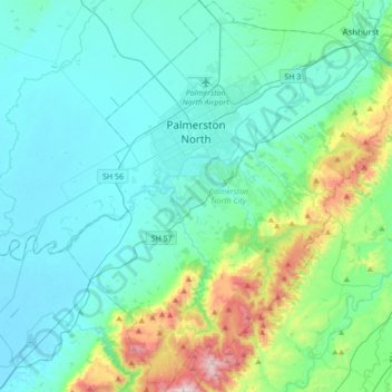
Name: Topografische Karte Palmerston North, Höhe, Relief.
Ort: Palmerston North, Manawatū-Whanganui, New Zealand (-40.52969 175.49733 -40.26808 175.79059)
Durchschnittliche Höhe: 133 m
Minimale Höhe: 4 m
Maximale Höhe: 756 m
Although the land Palmerston North is situated on is bounded by the lofty Ruahine and Tararua ranges in the east and south respectively, the city has a predominantly flat appearance. The occasional rise in elevation occurs further away from the river and is especially pronounced in the north and northeast, and also on the south side of the river. The typical urban area elevation ranges between 20–40 metres (65–130 ft) above sea level.
Andere topografische Karten
Klicken Sie auf eine Karte, um ihre Topografie, ihre Höhe und ihr Relief anzuzeigen.
Tongariro National Park
New Zealand > Manawatu-Whanganui > Ruapehu District
Tongariro National Park, Ruapehu District, Manawatū-Whanganui, New Zealand
Durchschnittliche Höhe: 888 m
Levin
New Zealand > Manawatu-Whanganui > Horowhenua District
Levin, Horowhenua District, Manawatū-Whanganui, 5510, New Zealand
Durchschnittliche Höhe: 41 m
Patata
New Zealand > Manawatu-Whanganui > Ruapehu District
Patata, Ruapehu District, Manawatū-Whanganui, 3990, New Zealand
Durchschnittliche Höhe: 356 m
Lake William
New Zealand > Manawatu-Whanganui > Rangitīkei District
Lake William, Rangitīkei District, Manawatū-Whanganui, New Zealand
Durchschnittliche Höhe: 100 m
Tararua District
New Zealand > Manawatu-Whanganui
Tararua District, Manawatū-Whanganui, New Zealand
Durchschnittliche Höhe: 246 m
Whanganui
New Zealand > Manawatu-Whanganui > Whanganui District
Whanganui, Whanganui District, Manawatū-Whanganui, 4500, New Zealand
Durchschnittliche Höhe: 74 m