
Topografische Karte Dodoma
Interaktive Karte
Klicken Sie auf die Karte, um die Höhe anzuzeigen.
Über diese Karte
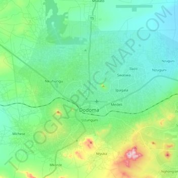
Name: Topografische Karte Dodoma, Höhe, Relief.
Ort: Dodoma, Dodoma City, Dodoma Region, Central Zone, Tanzania (-6.22852 35.67287 -6.08644 35.85797)
Durchschnittliche Höhe: 1.144 m
Minimale Höhe: 1.049 m
Maximale Höhe: 1.468 m
The official capital since 1996, Dodoma was envisaged as the first non-monumental capital city as opposed to the monumentality and hierarchy of other planned capital cities such as Abuja, Yamoussoukro, Brasília and Washington, D.C. It rejected geometrical forms such as grid iron and radial plans as inappropriate as the urban form was intended to undulate and curve with the existing topography and not in conflict with it so as to retain its rural ujamaa feel. As befitted Tanzania's development at the time, the car was seen as secondary in importance to public transports such as buses which were then utilised by much of the population.