
Topografische Karte Town of Prairie Lake
Interaktive Karte
Klicken Sie auf die Karte, um die Höhe anzuzeigen.
Über diese Karte
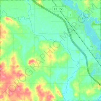
Name: Topografische Karte Town of Prairie Lake, Höhe, Relief.
Durchschnittliche Höhe: 335 m
Minimale Höhe: 312 m
Maximale Höhe: 390 m
Andere topografische Karten
Klicken Sie auf eine Karte, um ihre Topografie, ihre Höhe und ihr Relief anzuzeigen.
Heart Island
United States > Wisconsin > Barron County > Rice Lake
Heart Island, Rice Lake, Barron County, Wisconsin, 54868, United States
Durchschnittliche Höhe: 374 m
Turtle Lake
United States > Wisconsin > Barron County
Turtle Lake, Barron County, Wisconsin, United States
Durchschnittliche Höhe: 379 m
Town of Rice Lake
United States > Wisconsin > Barron County
Town of Rice Lake, Barron County, Wisconsin, United States
Durchschnittliche Höhe: 353 m
Chetek
United States > Wisconsin > Barron County
Chetek, Barron County, Wisconsin, 54728, United States
Durchschnittliche Höhe: 322 m
Town of Chetek
United States > Wisconsin > Barron County
Town of Chetek, Barron County, Wisconsin, United States
Durchschnittliche Höhe: 335 m
Rice Lake
United States > Wisconsin > Barron County
Rice Lake, Barron County, Wisconsin, 54868, United States
Durchschnittliche Höhe: 353 m