
Topografische Karte Monument Valley
Interaktive Karte
Klicken Sie auf die Karte, um die Höhe anzuzeigen.
Über diese Karte
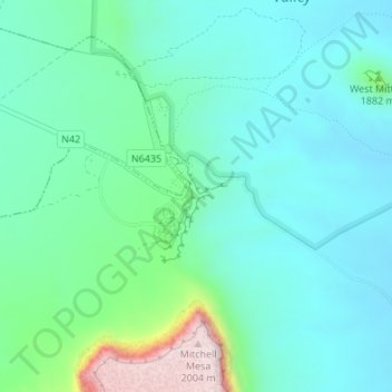
Name: Topografische Karte Monument Valley, Höhe, Relief.
Durchschnittliche Höhe: 1.675 m
Minimale Höhe: 1.585 m
Maximale Höhe: 2.009 m
The area is part of the Colorado Plateau. The elevation of the valley floor ranges from 5,000 to 6,000 feet (1,500 to 1,800 m) above sea level. The floor is largely siltstone of the Cutler Group, or sand derived from it, deposited by the meandering rivers that carved the valley. The valley's vivid red color comes from iron oxide exposed in the weathered siltstone. The darker, blue-gray rocks in the valley get their color from manganese oxide.
Andere topografische Karten
Klicken Sie auf eine Karte, um ihre Topografie, ihre Höhe und ihr Relief anzuzeigen.
Jeddito
United States > Arizona > Navajo County
Jeddito, Fort Defiance Agency, Navajo County, Arizona, United States
Durchschnittliche Höhe: 1.939 m
First Mesa
United States > Arizona > Navajo County
First Mesa, Navajo County, Arizona, United States
Durchschnittliche Höhe: 1.768 m
Winslow
United States > Arizona > Navajo County
Winslow, Navajo County, Arizona, United States
Durchschnittliche Höhe: 1.495 m
Heber
United States > Arizona > Navajo County
Heber, Navajo County, Arizona, 85928, United States
Durchschnittliche Höhe: 2.001 m