
Topografische Karte Chester
Interaktive Karte
Klicken Sie auf die Karte, um die Höhe anzuzeigen.
Über diese Karte
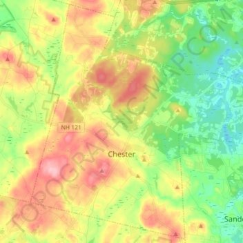
Name: Topografische Karte Chester, Höhe, Relief.
Durchschnittliche Höhe: 112 m
Minimale Höhe: 45 m
Maximale Höhe: 198 m
According to the United States Census Bureau, the town has a total area of 26.1 square miles (67.7 km2), of which 26.0 square miles (67.4 km2) are land and 0.12 square miles (0.3 km2), or 0.43%, are water. The highest point in town is found on an unnamed hill west of Bell Hill and northwest of Harantis Lake; it has two knobs of almost equal elevation of at least 635 feet (194 m), according to the most recent (2011–2012) USGS 7.5-minute topographical map. The Exeter River rises in Chester. The area of Chester drained by the Exeter and its tributary Towle Brook lies within the Piscataqua River (Coastal) watershed, while the western edge of town drains west toward Massabesic Lake and is in the Merrimack River watershed.