
Topografische Karte Hîncești District
Interaktive Karte
Klicken Sie auf die Karte, um die Höhe anzuzeigen.
Über diese Karte
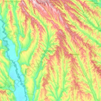
Name: Topografische Karte Hîncești District, Höhe, Relief.
Ort: Hîncești District, Moldova (46.60445 28.08293 47.08898 28.74293)
Durchschnittliche Höhe: 156 m
Minimale Höhe: 17 m
Maximale Höhe: 393 m
Hîncești District is located in the central part of the Republic of Moldova. Neighboring districts include Nisporeni District to the northwest, Strășeni District to the northeast, Ialoveni District to the east, Cimișlia and Leova districts to the south, and the border with Romania on the river Prut to the west. The topography is predominantly hilly with heights between 100 and 350 m. The landscape of the district is divided into three areas: the forested hills of Codru, the forested and less hilly steppe, and the steppe of Prut. The Codru forests are characterized by very complicated terrain. From north to south, the territory is intersected by the Cogâlnic River and the Galbena River. The forested steppe is characterized by gentler topography. The area is intersected by the Lapusna River and the Sărata River, a tributary of the Prut. The Prut steppe zone is characterized by a flatter and less wooded landscape. This area is crossed by the river Călmățui, which in Turkish translates as "white matter". Erosional processes differ in each area.
Andere topografische Karten
Klicken Sie auf eine Karte, um ihre Topografie, ihre Höhe und ihr Relief anzuzeigen.
Dubasari
Dubasari, Dubăsari town council, Dubăsari District, Dubasari District (Transnistria), Transnistria, MD-4817, Moldova, Dniester
Durchschnittliche Höhe: 51 m
Bender City Council
Bender City Council, Bender Municipality, Transnistria, Moldova
Durchschnittliche Höhe: 61 m
Vadul lui Vodă
Vadul lui Vodă, Ciocana Sector, Chișinău Municipality, MD-2046, Moldova
Durchschnittliche Höhe: 71 m
Tiraspol
Tiraspol, Administrative-Territorial Units of the Left Bank of the Dniester, Pridnestrovie, MD-3300, Moldova
Durchschnittliche Höhe: 38 m
Orhei
Moldova > Orhei District > Orhei
Orhei, Orhei District, 3505, Moldova
Durchschnittliche Höhe: 144 m
Rybnitsa
Moldova > Transnistria > Rybnitsa
Rybnitsa, Rybnitsa District, Administrative-Territorial Units from the Left Bank of the Dniester, Transnistria, Moldova
Durchschnittliche Höhe: 105 m
Băcioi Commune
Moldova > Chișinău Municipality > Băcioi Commune
Băcioi Commune, Botanica Sector, Chisinau Municipality, 6812, Moldova
Durchschnittliche Höhe: 115 m
Voinova
Moldova > Strășeni District > Voinova
Voinova, Strășeni District, Moldova
Durchschnittliche Höhe: 193 m
Bălănești Hill
Bălănești Hill, Nisporeni District, Moldova
Durchschnittliche Höhe: 345 m
Mayak
Moldova > Transnistria > Mayak
Mayak, Grigoriopol District, Administrative-Territorial Units from the Left Bank of the Dniester, Transnistria, 4006, Moldova
Durchschnittliche Höhe: 139 m
Tohatin Commune
Moldova > Chișinău Municipality > Tohatin Commune
Tohatin Commune, Ciocana, Chișinău Municipality, Moldova
Durchschnittliche Höhe: 139 m
Chirca
Moldova > Anenii Noi District > Chirca
Chirca, Anenii Noi District, Moldova
Durchschnittliche Höhe: 60 m
Nisporeni
Moldova > Nisporeni District > Nisporeni
Nisporeni, Nisporeni District, Moldova
Durchschnittliche Höhe: 170 m