
Topografische Karte Decatur
Interaktive Karte
Klicken Sie auf die Karte, um die Höhe anzuzeigen.
Über diese Karte
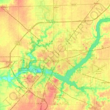
Name: Topografische Karte Decatur, Höhe, Relief.
Ort: Decatur, Macon County, Illinois, United States (39.78680 -89.03237 39.92496 -88.80320)
Durchschnittliche Höhe: 205 m
Minimale Höhe: 177 m
Maximale Höhe: 224 m
Andere topografische Karten
Klicken Sie auf eine Karte, um ihre Topografie, ihre Höhe und ihr Relief anzuzeigen.
Elwin
United States > Illinois > Macon County
Elwin, Macon County, Illinois, 62532, United States
Durchschnittliche Höhe: 216 m
Harristown
United States > Illinois > Macon County
Harristown, Macon County, Illinois, 62537, United States
Durchschnittliche Höhe: 200 m
Big Creek Park
United States > Illinois > Macon County > Decatur
Big Creek Park, Decatur, Macon County, Illinois, United States
Durchschnittliche Höhe: 201 m
Forsyth
United States > Illinois > Macon County > Forsyth
Forsyth, Macon County, Illinois, 62535, United States
Durchschnittliche Höhe: 206 m