
Spenden
Rüste dich für dein nächstes Abenteuer:
Als Amazon-Partner verdient diese Website an qualifizierten Käufen, ohne zusätzliche Kosten für Sie.
Topografische Karte Vallecito
Klicken Sie auf die Karte, um die Höhe anzuzeigen.
Spenden
Rüste dich für dein nächstes Abenteuer:
Als Amazon-Partner verdient diese Website an qualifizierten Käufen, ohne zusätzliche Kosten für Sie.
Über diese Karte
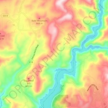
Name: Topografische Karte Vallecito, Höhe, Relief.
Ort: Vallecito, Calaveras County, California, United States (38.03821 -120.49748 38.10262 -120.42408)
Durchschnittliche Höhe: 526 m
Minimale Höhe: 297 m
Maximale Höhe: 766 m
Spenden
Rüste dich für dein nächstes Abenteuer:
Als Amazon-Partner verdient diese Website an qualifizierten Käufen, ohne zusätzliche Kosten für Sie.
Andere topografische Karten
Klicken Sie auf eine Karte, um ihre Topografie, ihre Höhe und ihr Relief anzuzeigen.
Campo Seco
United States > California > Calaveras County
Campo Seco (Spanish for "Dry Field") is an unincorporated community in Calaveras County, California. It sits at an elevation of 564 feet (172 m) above sea level and is located at 38°13′38″N 120°51′12″W / 38.22722°N 120.85333°W / 38.22722; -120.85333. The community is in ZIP code 95226 and area code 209.
Durchschnittliche Höhe: 185 m
Spenden
Rüste dich für dein nächstes Abenteuer:
Als Amazon-Partner verdient diese Website an qualifizierten Käufen, ohne zusätzliche Kosten für Sie.
Calaveras Big Trees State Park
United States > California > Calaveras County
Durchschnittliche Höhe: 1.375 m
Rail Road Flat
United States > California > Calaveras County
This historic mining town, elevation 2,600 feet (788 m), was named after primitive mule-drawn ore cars used here. There was never actually a railroad here. The town was established in 1849. It was the site of an Indian council as well as the center of rich placer and quartz mining. Its largest producer was the…
Durchschnittliche Höhe: 831 m
Spenden
Rüste dich für dein nächstes Abenteuer:
Als Amazon-Partner verdient diese Website an qualifizierten Käufen, ohne zusätzliche Kosten für Sie.
Oak Park Estates
United States > California > Calaveras County > San Andreas
Durchschnittliche Höhe: 355 m
Spenden
Rüste dich für dein nächstes Abenteuer:
Als Amazon-Partner verdient diese Website an qualifizierten Käufen, ohne zusätzliche Kosten für Sie.