
Topografische Karte Porompat
Interaktive Karte
Klicken Sie auf die Karte, um die Höhe anzuzeigen.
Über diese Karte
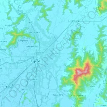
Name: Topografische Karte Porompat, Höhe, Relief.
Ort: Porompat, Imphal East District, Manipur, India (24.71864 93.89542 24.90691 94.01033)
Durchschnittliche Höhe: 821 m
Minimale Höhe: 769 m
Maximale Höhe: 1.557 m
Andere topografische Karten
Klicken Sie auf eine Karte, um ihre Topografie, ihre Höhe und ihr Relief anzuzeigen.
Tengnoupal
India > Manipur > Tengnoupal tehsil
Tengnoupal, Tengnoupal tehsil, Tengnoupal District, Manipur, India
Durchschnittliche Höhe: 1.220 m
Chakpikarong
Chakpikarong, Chandel, Manipur, 795102, India
Durchschnittliche Höhe: 927 m
Loktak Lake
India > Manipur > Bishnupur > Thanga
Loktak Lake, Thanga, Bishnupur, Manipur, India
Durchschnittliche Höhe: 772 m
Imphal
India > Manipur > Lamphelpat
Imphal, Lamphelpat, Imphal West District, Manipur, 795001, India
Durchschnittliche Höhe: 861 m