
Topografische Karte Wind Gap
Interaktive Karte
Klicken Sie auf die Karte, um die Höhe anzuzeigen.
Über diese Karte
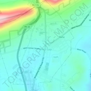
Name: Topografische Karte Wind Gap, Höhe, Relief.
Ort: Wind Gap, Northampton County, Pennsylvania, United States (40.83493 -75.30521 40.86362 -75.27978)
Durchschnittliche Höhe: 255 m
Minimale Höhe: 201 m
Maximale Höhe: 454 m
Wind Gap is located 21 miles (34 km) north of Allentown in the Lehigh Valley and 50 miles (80 km) southeast of Scranton, in the Wyoming Valley, or the Scranton/Wilkes-Barre metropolitan area. Wind Gap's elevation is 755 feet (230 m) above sea level.
Andere topografische Karten
Klicken Sie auf eine Karte, um ihre Topografie, ihre Höhe und ihr Relief anzuzeigen.
Hartzells Ferry
United States > Pennsylvania > Northampton County > Upper Mount Bethel Township > Hartzells Ferry
Hartzells Ferry, Upper Mount Bethel Township, Northampton County, Pennsylvania, 18343, United States
Durchschnittliche Höhe: 144 m