
Topografische Karte Barangay 201
Interaktive Karte
Klicken Sie auf die Karte, um die Höhe anzuzeigen.
Über diese Karte
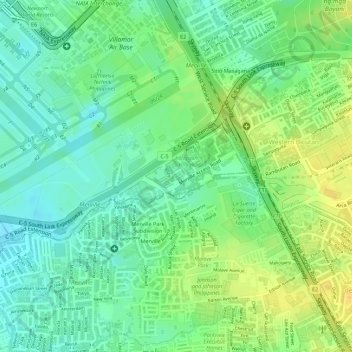
Name: Topografische Karte Barangay 201, Höhe, Relief.
Durchschnittliche Höhe: 19 m
Minimale Höhe: 6 m
Maximale Höhe: 33 m
Andere topografische Karten
Klicken Sie auf eine Karte, um ihre Topografie, ihre Höhe und ihr Relief anzuzeigen.
Barangay 159
Barangay 159, Zone 17, District 2, Pasay, Metro Manila, Philippines
Durchschnittliche Höhe: 9 m
Barangay 136
Barangay 136, Zone 13, District 2, Pasay, Southern Manila District, Metro Manila, Philippines
Durchschnittliche Höhe: 9 m
Pasay
Pasay, District 1, Pasay, Metro Manila, 1300, Philippines
Durchschnittliche Höhe: 14 m
Barangay 38
Barangay 38, Zone 5, Pasay, District 1, Pasay, Metro Manila, 1300, Philippines
Durchschnittliche Höhe: 7 m
Barangay 27
Barangay 27, Zone 4, Pasay, 1st District, Pasay, Metro Manila, 1300, Philippines
Durchschnittliche Höhe: 7 m