
Topografische Karte Gunny Sack Lake
Interaktive Karte
Klicken Sie auf die Karte, um die Höhe anzuzeigen.
Über diese Karte
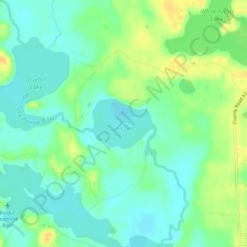
Name: Topografische Karte Gunny Sack Lake, Höhe, Relief.
Ort: Gunny Sack Lake, Itasca County, Minnesota, United States (47.60360 -93.39770 47.60909 -93.38706)
Durchschnittliche Höhe: 419 m
Minimale Höhe: 408 m
Maximale Höhe: 436 m
Andere topografische Karten
Klicken Sie auf eine Karte, um ihre Topografie, ihre Höhe und ihr Relief anzuzeigen.
Grand Rapids
United States > Minnesota > Itasca County
Grand Rapids, Itasca County, Minnesota, 55744, United States
Durchschnittliche Höhe: 398 m
Calumet
United States > Minnesota > Itasca County
Calumet, Itasca County, Minnesota, 55716, United States
Durchschnittliche Höhe: 421 m
Deer River
United States > Minnesota > Itasca County
Deer River, Itasca County, Minnesota, United States
Durchschnittliche Höhe: 393 m
Taconite
United States > Minnesota > Itasca County
Taconite, Itasca County, Minnesota, United States
Durchschnittliche Höhe: 420 m
Candy Lake
United States > Minnesota > Itasca County
Candy Lake, Itasca County, Minnesota, United States
Durchschnittliche Höhe: 421 m
Twin Lake Trails Mobile Home Park
United States > Minnesota > Itasca County
Twin Lake Trails Mobile Home Park, Itasca County, Minnesota, 55764, United States
Durchschnittliche Höhe: 419 m
Bovey
United States > Minnesota > Itasca County
Bovey, Itasca County, Minnesota, United States
Durchschnittliche Höhe: 417 m
La Prairie
United States > Minnesota > Itasca County
La Prairie, Itasca County, Minnesota, United States
Durchschnittliche Höhe: 393 m
Marble
United States > Minnesota > Itasca County
Marble, Itasca County, Minnesota, 55764, United States
Durchschnittliche Höhe: 427 m
Coleraine
United States > Minnesota > Itasca County > Coleraine
Coleraine, Itasca County, Minnesota, 55722, United States
Durchschnittliche Höhe: 408 m