
Spenden
Rüste dich für dein nächstes Abenteuer:
Als Amazon-Partner verdient diese Website an qualifizierten Käufen, ohne zusätzliche Kosten für Sie.
Topografische Karte Cookham Dean
Klicken Sie auf die Karte, um die Höhe anzuzeigen.
Spenden
Rüste dich für dein nächstes Abenteuer:
Als Amazon-Partner verdient diese Website an qualifizierten Käufen, ohne zusätzliche Kosten für Sie.
Über diese Karte
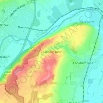
Name: Topografische Karte Cookham Dean, Höhe, Relief.
Durchschnittliche Höhe: 50 m
Minimale Höhe: 19 m
Maximale Höhe: 113 m
Spenden
Rüste dich für dein nächstes Abenteuer:
Als Amazon-Partner verdient diese Website an qualifizierten Käufen, ohne zusätzliche Kosten für Sie.
Andere topografische Karten
Klicken Sie auf eine Karte, um ihre Topografie, ihre Höhe und ihr Relief anzuzeigen.
Windsor Marina
United Kingdom > England > Royal Borough of Windsor and Maidenhead > Oakley Green
Durchschnittliche Höhe: 26 m
Bisham
United Kingdom > England > Royal Borough of Windsor and Maidenhead
Durchschnittliche Höhe: 63 m
Cookham
United Kingdom > England > Royal Borough of Windsor and Maidenhead
Durchschnittliche Höhe: 47 m
Sunningdale
United Kingdom > England > Royal Borough of Windsor and Maidenhead
Durchschnittliche Höhe: 61 m
Spenden
Rüste dich für dein nächstes Abenteuer:
Als Amazon-Partner verdient diese Website an qualifizierten Käufen, ohne zusätzliche Kosten für Sie.
Wraysbury
United Kingdom > England > Royal Borough of Windsor and Maidenhead
The new chapel, with its elegant slender tower, was opened on 16 October 1862; the building works had cost around £800. The striking terracotta relief panel, The City of Refuge, on the front elevation of the chapel, was created by the renowned Doulton & Co artist George Tinworth and is signed with his…
Durchschnittliche Höhe: 25 m
White Waltham
United Kingdom > England > Royal Borough of Windsor and Maidenhead
Durchschnittliche Höhe: 41 m
Shottesbrooke
United Kingdom > England > Royal Borough of Windsor and Maidenhead
Durchschnittliche Höhe: 41 m
Spenden
Rüste dich für dein nächstes Abenteuer:
Als Amazon-Partner verdient diese Website an qualifizierten Käufen, ohne zusätzliche Kosten für Sie.
Magna Carta Island
United Kingdom > England > Royal Borough of Windsor and Maidenhead > Wraysbury
Durchschnittliche Höhe: 32 m
Old Windsor
United Kingdom > England > Royal Borough of Windsor and Maidenhead
Durchschnittliche Höhe: 38 m
Bridge Gardens
United Kingdom > England > Royal Borough of Windsor and Maidenhead > Maidenhead
Durchschnittliche Höhe: 30 m
Hurley
United Kingdom > England > Royal Borough of Windsor and Maidenhead
Durchschnittliche Höhe: 67 m
Spenden
Rüste dich für dein nächstes Abenteuer:
Als Amazon-Partner verdient diese Website an qualifizierten Käufen, ohne zusätzliche Kosten für Sie.
Upton Court Park
United Kingdom > England > Royal Borough of Windsor and Maidenhead > Slough
Durchschnittliche Höhe: 23 m
Formosa Island
United Kingdom > England > Royal Borough of Windsor and Maidenhead > Cookham
Durchschnittliche Höhe: 48 m
Windsor Castle
United Kingdom > England > Royal Borough of Windsor and Maidenhead > Windsor > Clewer Village
Durchschnittliche Höhe: 23 m
Cox Green
United Kingdom > England > Royal Borough of Windsor and Maidenhead > Maidenhead
Durchschnittliche Höhe: 36 m
Spenden
Rüste dich für dein nächstes Abenteuer:
Als Amazon-Partner verdient diese Website an qualifizierten Käufen, ohne zusätzliche Kosten für Sie.
Eton Wick
United Kingdom > England > Royal Borough of Windsor and Maidenhead
Durchschnittliche Höhe: 22 m
Horton
United Kingdom > England > Royal Borough of Windsor and Maidenhead > Horton
Durchschnittliche Höhe: 18 m
Waltham St. Lawrence
United Kingdom > England > Royal Borough of Windsor and Maidenhead
Durchschnittliche Höhe: 44 m
Spenden
Rüste dich für dein nächstes Abenteuer:
Als Amazon-Partner verdient diese Website an qualifizierten Käufen, ohne zusätzliche Kosten für Sie.
Windsor Castle
United Kingdom > England > Royal Borough of Windsor and Maidenhead > Windsor > Clewer Village
Durchschnittliche Höhe: 23 m
Sunningdale
United Kingdom > England > Royal Borough of Windsor and Maidenhead
Durchschnittliche Höhe: 61 m
Windsor Castle
United Kingdom > England > Royal Borough of Windsor and Maidenhead > Windsor > Clewer Village
Durchschnittliche Höhe: 23 m
Spenden
Rüste dich für dein nächstes Abenteuer:
Als Amazon-Partner verdient diese Website an qualifizierten Käufen, ohne zusätzliche Kosten für Sie.
Wraysbury
United Kingdom > England > Royal Borough of Windsor and Maidenhead
The new chapel, with its elegant slender tower, was opened on 16 October 1862; the building works had cost around £800. The striking terracotta relief panel, The City of Refuge, on the front elevation of the chapel, was created by the renowned Doulton & Co artist George Tinworth and is signed with his…
Durchschnittliche Höhe: 26 m
Cookham
United Kingdom > England > Royal Borough of Windsor and Maidenhead
Durchschnittliche Höhe: 47 m
Windsor Castle
United Kingdom > England > Royal Borough of Windsor and Maidenhead > Windsor > Clewer Village
Durchschnittliche Höhe: 23 m
Spenden
Rüste dich für dein nächstes Abenteuer:
Als Amazon-Partner verdient diese Website an qualifizierten Käufen, ohne zusätzliche Kosten für Sie.