
Topografische Karte Astoria
Interaktive Karte
Klicken Sie auf die Karte, um die Höhe anzuzeigen.
Über diese Karte
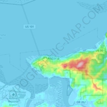
Name: Topografische Karte Astoria, Höhe, Relief.
Ort: Astoria, Clatsop County, Oregon, 97103, United States (46.16995 -123.87418 46.21494 -123.73924)
Durchschnittliche Höhe: 16 m
Minimale Höhe: -4 m
Maximale Höhe: 204 m
Andere topografische Karten
Klicken Sie auf eine Karte, um ihre Topografie, ihre Höhe und ihr Relief anzuzeigen.
Cannon Beach
United States > Oregon > Clatsop County
Cannon Beach, Clatsop County, Oregon, United States
Durchschnittliche Höhe: 42 m
Warrenton
United States > Oregon > Clatsop County
Warrenton, Clatsop County, Oregon, United States
Durchschnittliche Höhe: 4 m
Astoria
United States > Oregon > Clatsop County > Astoria
Astoria, Clatsop County, Oregon, 97103, United States
Durchschnittliche Höhe: 17 m
Westport
United States > Oregon > Clatsop County > Westport
Westport, Clatsop County, Oregon, United States
Durchschnittliche Höhe: 61 m