
Topografische Karte Laramie
Interaktive Karte
Klicken Sie auf die Karte, um die Höhe anzuzeigen.
Über diese Karte
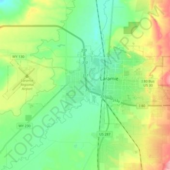
Name: Topografische Karte Laramie, Höhe, Relief.
Ort: Laramie, Albany County, Wyoming, United States (41.27742 -105.69729 41.33581 -105.52819)
Durchschnittliche Höhe: 2.219 m
Minimale Höhe: 2.166 m
Maximale Höhe: 2.462 m
Laramie is on a high plain between two mountain ranges, the Snowy Range, about 30 miles (48 km) to the west, and the Laramie Range, 7 miles (11 km) to the east. The city's elevation above sea level is approximately 7,165 feet (2,184 m). The Laramie River runs through Laramie toward its confluence with the North Platte River east of the Laramie Range.
Andere topografische Karten
Klicken Sie auf eine Karte, um ihre Topografie, ihre Höhe und ihr Relief anzuzeigen.
Laramie
United States > Wyoming > Albany County > Laramie
Laramie, Albany County, Wyoming, 82070, United States
Durchschnittliche Höhe: 2.299 m