
Topografische Karte Moneymore
Klicken Sie auf die Karte, um die Höhe anzuzeigen.
Über diese Karte
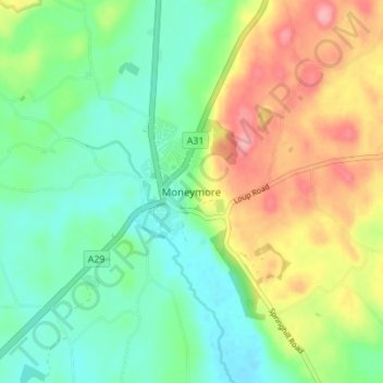
Name: Topografische Karte Moneymore, Höhe, Relief.
Durchschnittliche Höhe: 71 m
Minimale Höhe: 30 m
Maximale Höhe: 141 m
Andere topografische Karten
Klicken Sie auf eine Karte, um ihre Topografie, ihre Höhe und ihr Relief anzuzeigen.
Drumahoe
United Kingdom > Northern Ireland > County Londonderry > Derry/Londonderry
Durchschnittliche Höhe: 46 m
Causeway Coast and Glens District
United Kingdom > Northern Ireland > County Londonderry
Durchschnittliche Höhe: 101 m
Ballymagroarty
United Kingdom > Northern Ireland > County Londonderry > Derry/Londonderry
Durchschnittliche Höhe: 73 m
Mid-Ulster District Council
United Kingdom > Northern Ireland > County Londonderry
Durchschnittliche Höhe: 112 m
Foyle
United Kingdom > Northern Ireland > County Londonderry > Derry/Londonderry
Durchschnittliche Höhe: 48 m
River Roe
United Kingdom > Northern Ireland > County Londonderry > Limavady
Durchschnittliche Höhe: 27 m
Lough Foyle
United Kingdom > Northern Ireland > County Londonderry > Londonderry/Derry
Durchschnittliche Höhe: 61 m
Eglinton Registrars District
United Kingdom > Northern Ireland > County Londonderry > Greysteel
Durchschnittliche Höhe: 87 m
Foyle
United Kingdom > Northern Ireland > County Londonderry > Derry/Londonderry
Durchschnittliche Höhe: 48 m
Bay Road Park
United Kingdom > Northern Ireland > County Londonderry > Derry/Londonderry
Durchschnittliche Höhe: 19 m