
Topografische Karte Pen-y-ghent
Interaktive Karte
Klicken Sie auf die Karte, um die Höhe anzuzeigen.
Über diese Karte
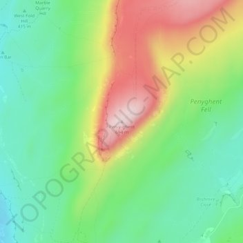
Name: Topografische Karte Pen-y-ghent, Höhe, Relief.
Durchschnittliche Höhe: 487 m
Minimale Höhe: 358 m
Maximale Höhe: 694 m
Andere topografische Karten
Klicken Sie auf eine Karte, um ihre Topografie, ihre Höhe und ihr Relief anzuzeigen.
Skipton
United Kingdom > England > North Yorkshire
Skipton, North Yorkshire, England, United Kingdom
Durchschnittliche Höhe: 173 m
Swilla Glen
United Kingdom > England > North Yorkshire > Thornton in Lonsdale
Swilla Glen, Thornton in Lonsdale, North Yorkshire, England, LA6 3JJ, United Kingdom
Durchschnittliche Höhe: 204 m
Ingleton
United Kingdom > England > North Yorkshire
Ingleton, North Yorkshire, England, United Kingdom
Durchschnittliche Höhe: 309 m
Settle
United Kingdom > England > North Yorkshire
Settle, North Yorkshire, England, United Kingdom
Durchschnittliche Höhe: 238 m
Appletreewick
United Kingdom > England > North Yorkshire
Appletreewick, North Yorkshire, England, United Kingdom
Durchschnittliche Höhe: 348 m
Catterick
United Kingdom > England > North Yorkshire
Catterick, North Yorkshire, England, United Kingdom
Durchschnittliche Höhe: 61 m
Harrogate
United Kingdom > England > North Yorkshire
Harrogate, North Yorkshire, England, United Kingdom
Durchschnittliche Höhe: 131 m
Bentham
United Kingdom > England > North Yorkshire > Craven District
Bentham, Craven District, North Yorkshire, England, United Kingdom
Durchschnittliche Höhe: 168 m
Muker
United Kingdom > England > North Yorkshire > Richmondshire
Muker, Richmondshire, North Yorkshire, England, United Kingdom
Durchschnittliche Höhe: 479 m