
Topografische Karte Grand Canyon National Park
Interaktive Karte
Klicken Sie auf die Karte, um die Höhe anzuzeigen.
Über diese Karte
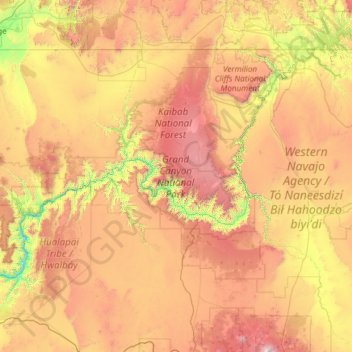
Name: Topografische Karte Grand Canyon National Park, Höhe, Relief.
Durchschnittliche Höhe: 1.685 m
Minimale Höhe: 513 m
Maximale Höhe: 3.757 m
The North Rim area of the park is located on the Kaibab Plateau and Walhalla Plateau, directly across the Grand Canyon from the principal visitor areas on the South Rim. The North Rim's principal visitor areas are centered around Bright Angel Point. The North Rim is higher in elevation than the South Rim, at over 8,000 feet (2,400 m) of elevation. Because it is so much higher than the South Rim, it is closed from December 1 through May 15 each year, due to the enhanced snowfall at elevation. Visitor services are closed or limited in scope after October 15. Driving time from the South Rim to the North Rim is about 4.5 hours, over 220 miles (350 km).
Andere topografische Karten
Klicken Sie auf eine Karte, um ihre Topografie, ihre Höhe und ihr Relief anzuzeigen.
Hoover Dam
United States > Arizona > Mohave County
Hoover Dam, Mohave County, Arizona, United States
Durchschnittliche Höhe: 429 m
Pyramid Rock
United States > Arizona > Mohave County
Pyramid Rock, Mohave County, Arizona, United States
Durchschnittliche Höhe: 1.419 m
Lake Havasu City
United States > Arizona > Mohave County > Lake Havasu City
Lake Havasu City, Mohave County, Arizona, 86403, United States
Durchschnittliche Höhe: 411 m
Centennial Park
United States > Arizona > Mohave County
Centennial Park, Mohave County, Arizona, 86021, United States
Durchschnittliche Höhe: 1.504 m