
Topografische Karte Dover
Interaktive Karte
Klicken Sie auf die Karte, um die Höhe anzuzeigen.
Über diese Karte
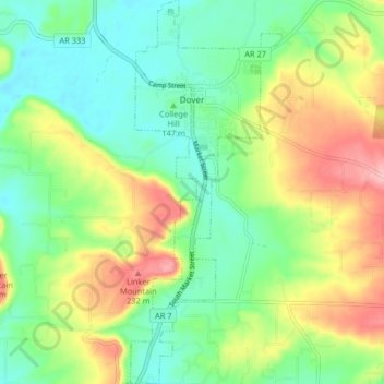
Name: Topografische Karte Dover, Höhe, Relief.
Ort: Dover, Pope County, Arkansas, 72837, United States (35.35115 -93.12742 35.41773 -93.09518)
Durchschnittliche Höhe: 164 m
Minimale Höhe: 113 m
Maximale Höhe: 252 m
The mild hills historically supported oak-hickory forest or oak-hickory-pine forest. Elevation changes and soil types make the Arkansas Valley Hills largely unsuitable for row agriculture. Instead, forest has been cleared for pastureland, poultry farming or ranching. Logging remains an important land use where elevation or soil makes livestock farming unsuitable. Many of the smaller streams and watercourses are completely dry in summer.
Andere topografische Karten
Klicken Sie auf eine Karte, um ihre Topografie, ihre Höhe und ihr Relief anzuzeigen.
Smyrna
United States > Arkansas > Pope County
Smyrna, Pope County, Arkansas, United States
Durchschnittliche Höhe: 402 m
Russellville
United States > Arkansas > Pope County
Russellville, Pope County, Arkansas, United States
Durchschnittliche Höhe: 133 m
Dover
United States > Arkansas > Pope County > Dover > Dover
Dover, Pope County, Arkansas, 72837, United States
Durchschnittliche Höhe: 150 m
Moreland
United States > Arkansas > Pope County > Moreland
Moreland, Pope County, Arkansas, 72802:72837, United States
Durchschnittliche Höhe: 236 m
Worthen
United States > Arkansas > Pope County > Pottsville
Worthen, Pottsville, Pope County, Arkansas, 72858, United States
Durchschnittliche Höhe: 143 m