
Spenden
Rüste dich für dein nächstes Abenteuer:
Als Amazon-Partner verdient diese Website an qualifizierten Käufen, ohne zusätzliche Kosten für Sie.
Topografische Karte Anderson Valley
Klicken Sie auf die Karte, um die Höhe anzuzeigen.
Spenden
Rüste dich für dein nächstes Abenteuer:
Als Amazon-Partner verdient diese Website an qualifizierten Käufen, ohne zusätzliche Kosten für Sie.
Anderson Valley
The climate is tempered by cool marine air. Steep hills and mountains surround rolling to nearly level alluvial terraces. The dominant natural vegetation is a mixed forest of Coast Redwood, various native oak varieties, and Douglas fir. Elevation ranges from sea level to 2,500 feet (760 m). The average annual precipitation ranges 35 to 80 inches (890 to 2,030 mm). The average annual temperature is about 53 °F (12 °C), and the average frost-free season ranges from 220 to 365 days. Towards the coast the summers are cool and moist with frequent fog, while the interior Anderson Valley proper features a warm to hot summer climate similar to nearby interior regions, with daytime highs occasionally in excess of 100 °F (38 °C).
Spenden
Rüste dich für dein nächstes Abenteuer:
Als Amazon-Partner verdient diese Website an qualifizierten Käufen, ohne zusätzliche Kosten für Sie.
Über diese Karte
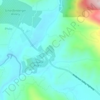
Name: Topografische Karte Anderson Valley, Höhe, Relief.
Durchschnittliche Höhe: 129 m
Minimale Höhe: 54 m
Maximale Höhe: 447 m
Spenden
Rüste dich für dein nächstes Abenteuer:
Als Amazon-Partner verdient diese Website an qualifizierten Käufen, ohne zusätzliche Kosten für Sie.
Andere topografische Karten
Klicken Sie auf eine Karte, um ihre Topografie, ihre Höhe und ihr Relief anzuzeigen.
Boonville
United States > California > Mendocino County
Boonville (formerly The Corners and Kendall's City) is a census-designated place (CDP) in Mendocino County, California, United States. It is located 12.5 miles (20 km) southwest of Ukiah, at an elevation of 381 feet (116 m). The population was 1,018 at the 2020 census.
Durchschnittliche Höhe: 168 m
Laytonville
United States > California > Mendocino County > Laytonville
Laytonville is a census-designated place (CDP) in Mendocino County, California, United States. Laytonville, is located 20 miles (32 km) north-northwest of Willits, at an elevation of 1670 feet (509 m). The population was 1,227 at the 2010 census, down from 1,301 at the 2000 census.
Durchschnittliche Höhe: 536 m
Spenden
Rüste dich für dein nächstes Abenteuer:
Als Amazon-Partner verdient diese Website an qualifizierten Käufen, ohne zusätzliche Kosten für Sie.
Philo
United States > California > Mendocino County
Philo is a census-designated place in Mendocino County, California, United States. It is located 6 miles (10 km) northwest of Boonville, at an elevation of 331 feet (101 m). The population was 319 at the 2020 census.
Durchschnittliche Höhe: 111 m
Redwood Valley
United States > California > Mendocino County
Redwood Valley (formerly Basil) is a census-designated place (CDP) in Mendocino County, California, United States. It is located 9 miles (14 km) north of Ukiah, the county seat, at an elevation of 722 feet (220 m), and comprises the northern portion of the Ukiah Valley. It is about 15 miles (24 km) southeast…
Durchschnittliche Höhe: 246 m
Fort Bragg
United States > California > Mendocino County
Fort Bragg is a city along the North Coast of California in Mendocino County. The city is 24 miles (39 km) west of Willits, at an elevation of 85 feet (26 m). Its population was 6,983 at the 2020 census.
Durchschnittliche Höhe: 23 m
Spenden
Rüste dich für dein nächstes Abenteuer:
Als Amazon-Partner verdient diese Website an qualifizierten Käufen, ohne zusätzliche Kosten für Sie.
Covelo
United States > California > Mendocino County
Covelo (/ˈkoʊvəloʊ/ KOH-və-loh) is a census-designated place (CDP) in Mendocino County, California, United States. Covelo is located 14 miles (23 km) east-northeast of Laytonville, at an elevation of 1,398 feet (426 m). The population was 1,394 at the 2020 census, up from 1,255 at the 2010 census. 405…
Durchschnittliche Höhe: 440 m
Potter Valley
United States > California > Mendocino County
Potter Valley is a census-designated place in Mendocino County, California, United States. It is located 18 miles (29 km) north-northeast of Ukiah, at an elevation of 948 feet (289 m) at the headwaters of the East Fork Russian River. The CDP population was 665 at the 2020 census.
Durchschnittliche Höhe: 317 m
Spenden
Rüste dich für dein nächstes Abenteuer:
Als Amazon-Partner verdient diese Website an qualifizierten Käufen, ohne zusätzliche Kosten für Sie.
Fort Bragg
United States > California > Mendocino County
Fort Bragg is a city along the North Coast of California in Mendocino County. The city is 24 miles (39 km) west of Willits, at an elevation of 85 feet (26 m). Its population was 6,983 at the 2020 census.
Durchschnittliche Höhe: 36 m
Fort Bragg
United States > California > Mendocino County
Fort Bragg is a city along the North Coast of California in Mendocino County. The city is 24 miles (39 km) west of Willits, at an elevation of 85 feet (26 m). Its population was 6,983 at the 2020 census.
Durchschnittliche Höhe: 23 m
Laytonville
United States > California > Mendocino County > Laytonville
Laytonville is a census-designated place (CDP) in Mendocino County, California, United States. It is located 23 miles (37 km) north-northwest of Willits, at an elevation of 1,670 feet (510 m). The population was 1,152 at the 2020 census, down from 1,227 at the 2010 census.
Durchschnittliche Höhe: 536 m
Spenden
Rüste dich für dein nächstes Abenteuer:
Als Amazon-Partner verdient diese Website an qualifizierten Käufen, ohne zusätzliche Kosten für Sie.
Philo
United States > California > Mendocino County
Philo is a census-designated place in Mendocino County, California, United States. It is located 6 miles (10 km) northwest of Boonville, at an elevation of 331 feet (101 m). The population was 319 at the 2020 census.
Durchschnittliche Höhe: 111 m
Fort Bragg
United States > California > Mendocino County
Fort Bragg is a city along the North Coast of California in Mendocino County. The city is 24 miles (39 km) west of Willits, at an elevation of 85 feet (26 m). Its population was 6,983 at the 2020 census.
Durchschnittliche Höhe: 23 m
Potter Valley
United States > California > Mendocino County > Potter Valley
Potter Valley is a census-designated place in Mendocino County, California, United States. It is located 18 miles (29 km) north-northeast of Ukiah, at an elevation of 948 feet (289 m) at the headwaters of the East Fork Russian River. The CDP population was 665 at the 2020 census.
Durchschnittliche Höhe: 317 m
Spenden
Rüste dich für dein nächstes Abenteuer:
Als Amazon-Partner verdient diese Website an qualifizierten Käufen, ohne zusätzliche Kosten für Sie.
Fort Bragg
United States > California > Mendocino County > Fort Bragg
Fort Bragg, officially the City of Fort Bragg, is a city along the Pacific Coast of California along Shoreline Highway in Mendocino County. It is 24 mi (39 km) west of Willits, at an elevation of 85 feet (26 m). Its population was 6,983 at the 2020 census.
Durchschnittliche Höhe: 29 m