
Topografische Karte Cormontreuil
Interaktive Karte
Klicken Sie auf die Karte, um die Höhe anzuzeigen.
Über diese Karte
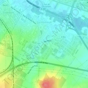
Name: Topografische Karte Cormontreuil, Höhe, Relief.
Durchschnittliche Höhe: 98 m
Minimale Höhe: 77 m
Maximale Höhe: 159 m
Andere topografische Karten
Klicken Sie auf eine Karte, um ihre Topografie, ihre Höhe und ihr Relief anzuzeigen.
Les Côtes Jopin
France > Grand Est > Marne > Changy
Les Côtes Jopin, Changy, Vitry-le-François, Marne, Grand Est, Metropolitan France, 51300, France
Durchschnittliche Höhe: 132 m
Mourmelon-le-Grand
Mourmelon-le-Grand, Châlons-en-Champagne, Marne, Grand Est, Metropolitan France, 51400, France
Durchschnittliche Höhe: 124 m
Saint-Memmie
Saint-Memmie, Châlons-en-Champagne, Marne, Grand Est, Metropolitan France, 51470, France
Durchschnittliche Höhe: 98 m
Croix Allart
France > Grand Est > Marne > Bétheny
Croix Allart, Bétheny, Reims, Marne, Grand Est, Metropolitan France, 51450, France
Durchschnittliche Höhe: 94 m
Saint-Brice-Courcelles
Saint-Brice-Courcelles, Reims, Marne, Grand Est, Metropolitan France, 51370, France
Durchschnittliche Höhe: 79 m
Montmirail
Montmirail, Épernay, Marne, Grand Est, Metropolitan France, 51210, France
Durchschnittliche Höhe: 188 m
Witry-lès-Reims
Witry-lès-Reims, Reims, Marne, Grand Est, Metropolitan France, 51420, France
Durchschnittliche Höhe: 119 m
Vitry-le-François
Vitry-le-François, Marne, Grand Est, Metropolitan France, 51300, France
Durchschnittliche Höhe: 101 m
Aÿ-Champagne
Aÿ-Champagne, Épernay, Marne, Grand Est, Metropolitan France, France
Durchschnittliche Höhe: 127 m
Champguyon
Champguyon, Épernay, Marne, Grand Est, Metropolitan France, 51310, France
Durchschnittliche Höhe: 181 m
Saint-Gilles
Saint-Gilles, Reims, Marne, Grand Est, Metropolitan France, 51170, France
Durchschnittliche Höhe: 118 m
Hautvillers
Hautvillers, Épernay, Marne, Grand Est, Metropolitan France, 51160, France
Durchschnittliche Höhe: 178 m
Rilly-la-Montagne
Rilly-la-Montagne, Reims, Marne, Grand Est, Metropolitan France, 51500, France
Durchschnittliche Höhe: 188 m
La Chaussée de Damery
La Chaussée de Damery, Vauciennes, Épernay, Marne, Grand Est, Metropolitan France, 51480, France
Durchschnittliche Höhe: 136 m
Courtagnon
Courtagnon, Reims, Marne, Grand Est, Metropolitan France, 51480, France
Durchschnittliche Höhe: 224 m
Les Métairies
France > Grand Est > Marne > Rilly-la-Montagne
Les Métairies, Rilly-la-Montagne, Reims, Marne, Grand Est, Metropolitan France, 51500, France
Durchschnittliche Höhe: 210 m
Montchenot
Montchenot, Villers-Allerand, Reims, Marne, Grand Est, Metropolitan France, 51500, France
Durchschnittliche Höhe: 187 m
Avenay-Val-d'Or
Avenay-Val-d'Or, Épernay, Marne, Grand Est, Metropolitan France, 51160, France
Durchschnittliche Höhe: 147 m
Condé-sur-Marne
Condé-sur-Marne, Châlons-en-Champagne, Marne, Grand Est, Metropolitan France, 51150, France
Durchschnittliche Höhe: 87 m
Le Chemin de Pierre Morain
France > Grand Est > Marne > Clamanges
Le Chemin de Pierre Morain, Clamanges, Épernay, Marne, Grand Est, Metropolitan France, 51130, France
Durchschnittliche Höhe: 137 m
Bergères-lès-Vertus
France > Grand Est > Marne > Bergères-lès-Vertus
Bergères-lès-Vertus, Épernay, Marne, Grand Est, Metropolitan France, 51130, France
Durchschnittliche Höhe: 146 m
Charleville
Charleville, Épernay, Marne, Grand Est, Metropolitan France, 51120, France
Durchschnittliche Höhe: 203 m
Isles-sur-Suippe
Isles-sur-Suippe, Reims, Marne, Grand Est, Metropolitan France, 51110, France
Durchschnittliche Höhe: 92 m
Coupéville
Coupéville, Châlons-en-Champagne, Marne, Grand Est, Metropolitan France, 51240, France
Durchschnittliche Höhe: 162 m