
Topografische Karte Ashton
Interaktive Karte
Klicken Sie auf die Karte, um die Höhe anzuzeigen.
Über diese Karte
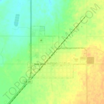
Name: Topografische Karte Ashton, Höhe, Relief.
Ort: Ashton, Fremont County, Idaho, United States (44.06777 -111.45714 44.08123 -111.43578)
Durchschnittliche Höhe: 1.601 m
Minimale Höhe: 1.585 m
Maximale Höhe: 1.614 m
Seed potatoes Ashton was first and foremost a farming community, as the soil of the area is rich and the water is plentiful. Shortly after the first settlers arrived in the 1890s, several canals were developed to divert water from streams running off the Yellowstone Plateau and Teton Range. Some farmland, mostly to the east, is high enough and close enough to the Teton Range that crops can grow without irrigation due to increased rainfall. The relatively high altitude limited crops to those requiring a short growing season such as grain and alfalfa. Seed potatoes were not tried as a crop until 1920 but as it turns out, the area is perfect for seed potatoes. The short growing season keeps the potatoes desirably small, and the long, cold winters create the ideal conditions for seed. The longtime enemy to potato farming is potato blight, a form of mold that reproduces from spores in the soil and sickens the potato plant. Ashton's winters clean the soil of these mold spores with a long, deep and killing freeze. Potato blight never spreads because the soil is clean and free of spores each spring. After realizing this, farmers organized, hired inspectors, and began selling certified seed potatoes giving buyers comfort that Ashton seed was free of molds and disease. This enabled them to demand a premium price for these potatoes grown in the clean soils around Ashton and the area quickly became the largest seed potato producing area in the world as it is still known today.
Andere topografische Karten
Klicken Sie auf eine Karte, um ihre Topografie, ihre Höhe und ihr Relief anzuzeigen.
Island Park
United States > Idaho > Fremont County
Island Park, Fremont County, Idaho, United States
Durchschnittliche Höhe: 2.113 m
St. Anthony
United States > Idaho > Fremont County
St. Anthony, Fremont County, Idaho, United States
Durchschnittliche Höhe: 1.515 m
Box Canyon
United States > Idaho > Fremont County
Box Canyon, Fremont County, Idaho, United States
Durchschnittliche Höhe: 1.891 m
Sawtell Peak
United States > Idaho > Fremont County
Sawtell Peak, Fremont County, Idaho, United States
Durchschnittliche Höhe: 2.661 m
Harriman State Park
United States > Idaho > Fremont County
Harriman State Park, Fremont County, Idaho, United States
Durchschnittliche Höhe: 1.888 m
Jefferson Mount
United States > Idaho > Fremont County
Jefferson Mount, Fremont County, Idaho, United States
Durchschnittliche Höhe: 2.767 m
American Legion / Daughters of Utah Pioneers Park
United States > Idaho > Fremont County > St. Anthony
American Legion / Daughters of Utah Pioneers Park, St. Anthony, Fremont County, Idaho, United States
Durchschnittliche Höhe: 1.515 m
Island Park
United States > Idaho > Fremont County
Island Park, Fremont County, Idaho, 83433, United States
Durchschnittliche Höhe: 1.962 m
Squirrel
United States > Idaho > Fremont County
Squirrel, Fremont County, Idaho, United States
Durchschnittliche Höhe: 1.711 m
Mesa Falls
United States > Idaho > Fremont County
Mesa Falls, Fremont County, Idaho, United States
Durchschnittliche Höhe: 1.800 m
Warm River
United States > Idaho > Fremont County > Warm River
Warm River, Fremont County, Idaho, United States
Durchschnittliche Höhe: 1.692 m
Henrys Lake
United States > Idaho > Fremont County > Island Park
Henrys Lake, Island Park, Fremont County, Idaho, United States
Durchschnittliche Höhe: 2.000 m