
Topografische Karte Clarkia
Interaktive Karte
Klicken Sie auf die Karte, um die Höhe anzuzeigen.
Über diese Karte
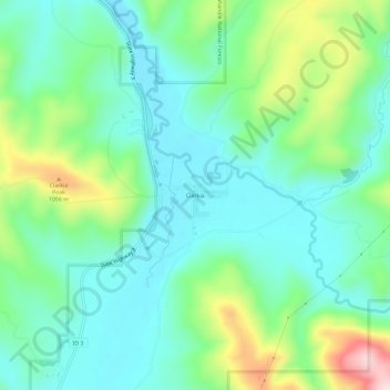
Name: Topografische Karte Clarkia, Höhe, Relief.
Ort: Clarkia, Shoshone County, Idaho, 83812, United States (46.99074 -116.27293 47.03074 -116.23293)
Durchschnittliche Höhe: 929 m
Minimale Höhe: 847 m
Maximale Höhe: 1.150 m
Andere topografische Karten
Klicken Sie auf eine Karte, um ihre Topografie, ihre Höhe und ihr Relief anzuzeigen.
Devils Pulpit
United States > Idaho > Shoshone County
Devils Pulpit, Shoshone County, Idaho, United States
Durchschnittliche Höhe: 1.116 m
Canyon Peak
United States > Idaho > Shoshone County
Canyon Peak, Shoshone County, Idaho, United States
Durchschnittliche Höhe: 1.203 m
Pinehurst
United States > Idaho > Shoshone County
Pinehurst, Shoshone County, Idaho, 83850, United States
Durchschnittliche Höhe: 729 m
Kingston
United States > Idaho > Shoshone County
Kingston, Shoshone County, Idaho, 83839, United States
Durchschnittliche Höhe: 730 m
Wallace
United States > Idaho > Shoshone County
Wallace, Shoshone County, Idaho, 83873, United States
Durchschnittliche Höhe: 991 m
Pocono
United States > Idaho > Shoshone County
Pocono, Shoshone County, Idaho, United States
Durchschnittliche Höhe: 895 m
McDonalds
United States > Idaho > Shoshone County > McDonalds
McDonalds, Shoshone County, Idaho, United States
Durchschnittliche Höhe: 1.692 m
Osburn
United States > Idaho > Shoshone County
Osburn, Shoshone County, Idaho, 83849, United States
Durchschnittliche Höhe: 934 m
Kellogg
United States > Idaho > Shoshone County
Kellogg, Shoshone County, Idaho, 83837, United States
Durchschnittliche Höhe: 939 m
Mullan
United States > Idaho > Shoshone County
Mullan, Shoshone County, Idaho, 83846, United States
Durchschnittliche Höhe: 1.168 m