
Topografische Karte Hanauma Bay
Interaktive Karte
Klicken Sie auf die Karte, um die Höhe anzuzeigen.
Über diese Karte
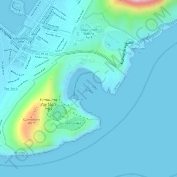
Name: Topografische Karte Hanauma Bay, Höhe, Relief.
Ort: Hanauma Bay, Honolulu County, Hawaii, 96825, United States (21.26957 -157.69386 21.26967 -157.69376)
Durchschnittliche Höhe: 32 m
Minimale Höhe: -2 m
Maximale Höhe: 261 m
Approximately 3.9 million years ago, the Waiʻanae volcano created the island of Oʻahu. About 2.5 million years ago, the Koʻolau volcano breached the ocean's surface and continued to grow in elevation until about 1.7 million years ago, when it went dormant. Most of the eastern or windward portion of Oʻahu are remnants of this volcano. Most of the familiar geographic landmarks of eastern Oʻahu were created by eruptions from Koʻolau from about 500,000 to 10,000 years ago. The eastern flank of the Koʻolau volcano including the caldera slid into the sea, leaving the Koʻolau mountain range that can be seen today on the windward side of the island.
Andere topografische Karten
Klicken Sie auf eine Karte, um ihre Topografie, ihre Höhe und ihr Relief anzuzeigen.
Honolulu
United States > Hawaii > Honolulu County
Honolulu, Honolulu County, Hawaii, United States
Durchschnittliche Höhe: 90 m
Mililani Mauka
United States > Hawaii > Honolulu County > Waipahu
Mililani Mauka, Waipahu, Honolulu County, Hawaii, United States
Durchschnittliche Höhe: 254 m
East Honolulu
United States > Hawaii > Honolulu County
East Honolulu, Honolulu County, Hawaii, 96825, United States
Durchschnittliche Höhe: 50 m
Haleiwa
United States > Hawaii > Honolulu County
Haleiwa, Honolulu County, Hawaii, United States
Durchschnittliche Höhe: 14 m
Oʻahu
United States > Hawaii > Honolulu County
Oʻahu, Honolulu County, Hawaii, United States
Durchschnittliche Höhe: 79 m
Mililani
United States > Hawaii > Honolulu County > Mililani
Mililani, Honolulu County, Hawaii, 96789, United States
Durchschnittliche Höhe: 206 m
Alan Davis Beach
United States > Hawaii > Honolulu County > Honolulu
Alan Davis Beach, Kalama Valley, Honolulu, Honolulu County, Hawaii, United States
Durchschnittliche Höhe: 26 m
Honolulu
United States > Hawaii > Honolulu County
Honolulu, Honolulu County, Hawaii, 96813, United States
Durchschnittliche Höhe: 71 m
Mililani Town
United States > Hawaii > Honolulu County
Mililani Town, Honolulu County, Hawaii, 96789, United States
Durchschnittliche Höhe: 183 m
Makaha Valley
United States > Hawaii > Honolulu County > Mākaha Valley
Makaha Valley, Mākaha Valley, Honolulu County, Hawaii, United States
Durchschnittliche Höhe: 173 m
Necker Island
United States > Hawaii > Honolulu County
Necker Island, Honolulu County, Hawaii, United States
Durchschnittliche Höhe: 0 m
Pearl City
United States > Hawaii > Honolulu County
Pearl City, Honolulu County, Hawaii, 96782, United States
Durchschnittliche Höhe: 65 m
Pupukea
United States > Hawaii > Honolulu County
Pupukea, Pūpūkea, Honolulu County, Hawaii, United States
Durchschnittliche Höhe: 51 m
Aiea
United States > Hawaii > Honolulu County > Aiea
Aiea, Honolulu County, Hawaii, United States
Durchschnittliche Höhe: 90 m
Waipahu
United States > Hawaii > Honolulu County
Waipahu, Honolulu County, Hawaii, 96797, United States
Durchschnittliche Höhe: 164 m
Diamond Head
United States > Hawaii > Honolulu County > Honolulu
Diamond Head, Honolulu, Honolulu County, Hawaii, 96815, United States
Durchschnittliche Höhe: 26 m
Kailua
United States > Hawaii > Honolulu County
Kailua, Honolulu County, Hawaii, United States
Durchschnittliche Höhe: 20 m