
Topografische Karte Faunce
Interaktive Karte
Klicken Sie auf die Karte, um die Höhe anzuzeigen.
Über diese Karte
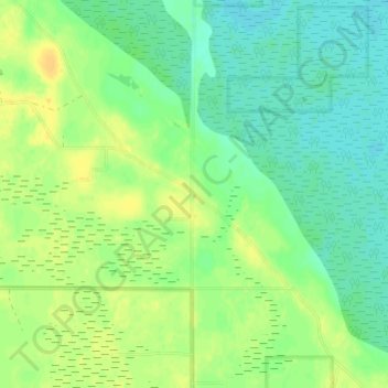
Name: Topografische Karte Faunce, Höhe, Relief.
Ort: Faunce, Lake of the Woods County, Minnesota, United States (48.57303 -94.97245 48.61303 -94.93245)
Durchschnittliche Höhe: 388 m
Minimale Höhe: 378 m
Maximale Höhe: 400 m
Andere topografische Karten
Klicken Sie auf eine Karte, um ihre Topografie, ihre Höhe und ihr Relief anzuzeigen.
Baudette
United States > Minnesota > Lake of the Woods County
Baudette, Lake of the Woods County, Minnesota, United States
Durchschnittliche Höhe: 331 m
Angle Inlet
United States > Minnesota > Lake of the Woods County
Angle Inlet, Lake of the Woods County, Minnesota, 56711, United States
Durchschnittliche Höhe: 327 m
Williams
United States > Minnesota > Lake of the Woods County
Williams, Lake of the Woods County, Minnesota, United States
Durchschnittliche Höhe: 352 m
Baudette
United States > Minnesota > Lake of the Woods County > Baudette > Baudette
Baudette, Lake of the Woods County, Minnesota, United States
Durchschnittliche Höhe: 331 m