
Topografische Karte North Liberty
Interaktive Karte
Klicken Sie auf die Karte, um die Höhe anzuzeigen.
Über diese Karte
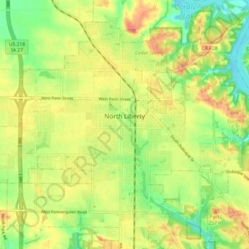
Name: Topografische Karte North Liberty, Höhe, Relief.
Ort: North Liberty, Johnson County, Iowa, 52317, United States (41.71922 -91.65163 41.77198 -91.56608)
Durchschnittliche Höhe: 235 m
Minimale Höhe: 206 m
Maximale Höhe: 262 m
North Liberty is located on the Iowan erosion surface. Drivers on I-380 experience an abrupt transition from the muted topography of the Iowan surface to the rolling hills of the Southern Iowa drift plain, four miles south of North Liberty.
Andere topografische Karten
Klicken Sie auf eine Karte, um ihre Topografie, ihre Höhe und ihr Relief anzuzeigen.
Tiffin
United States > Iowa > Johnson County
Tiffin, Johnson County, Iowa, 52340, United States
Durchschnittliche Höhe: 227 m
Coralville
United States > Iowa > Johnson County
Coralville, Johnson County, Iowa, 52241, United States
Durchschnittliche Höhe: 224 m
Iowa City
United States > Iowa > Johnson County > Iowa City
Iowa City, Johnson County, Iowa, 52240-5544, United States
Durchschnittliche Höhe: 225 m
Hills
United States > Iowa > Johnson County
Hills, Johnson County, Iowa, 52235, United States
Durchschnittliche Höhe: 196 m
Iowa City
United States > Iowa > Johnson County
Iowa City, Johnson County, Iowa, United States
Durchschnittliche Höhe: 216 m