
Topografische Karte Carlsbad
Interaktive Karte
Klicken Sie auf die Karte, um die Höhe anzuzeigen.
Über diese Karte
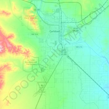
Name: Topografische Karte Carlsbad, Höhe, Relief.
Ort: Carlsbad, Eddy County, New Mexico, 88220, United States (32.29829 -104.28964 32.47653 -104.13431)
Durchschnittliche Höhe: 983 m
Minimale Höhe: 925 m
Maximale Höhe: 1.159 m
Carlsbad is located near the center of Eddy County at 32°24′43″N 104°14′11″W / 32.41194°N 104.23639°W / 32.41194; -104.23639 (32.407577, -104.245167) at an elevation of 3,295 feet (1,004 m). Carlsbad is situated in the northern reaches of the Chihuahuan Desert ecoregion, in the lower Pecos River Valley. Via US 285 it is 36 miles (58 km) north to Artesia and 86 miles (138 km) south to Pecos, Texas. US Routes 62 and 180 lead northeast 69 miles (111 km) to Hobbs and southwest 169 miles (272 km) to El Paso.
Andere topografische Karten
Klicken Sie auf eine Karte, um ihre Topografie, ihre Höhe und ihr Relief anzuzeigen.
Tecolote Peak
United States > New Mexico > Eddy County
Tecolote Peak, Eddy County, New Mexico, United States
Durchschnittliche Höhe: 968 m
Carlsbad Cavern
United States > New Mexico > Eddy County
Carlsbad Cavern, Natural Entrance Path, Eddy County, New Mexico, United States
Durchschnittliche Höhe: 1.274 m