
Topografische Karte Keriquel Vihan
Interaktive Karte
Klicken Sie auf die Karte, um die Höhe anzuzeigen.
Über diese Karte
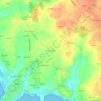
Name: Topografische Karte Keriquel Vihan, Höhe, Relief.
Durchschnittliche Höhe: 24 m
Minimale Höhe: -1 m
Maximale Höhe: 46 m
Andere topografische Karten
Klicken Sie auf eine Karte, um ihre Topografie, ihre Höhe und ihr Relief anzuzeigen.
Penanros
France > Bretagne > Finistère > Saint-Philibert
Penanros, Saint-Philibert, Trégunc, Quimper, Finistère, Bretagne, France métropolitaine, 29910, France
Durchschnittliche Höhe: 13 m
Kericuff
France > Bretagne > Finistère > Saint-Philibert
Kericuff, Saint-Philibert, Trégunc, Quimper, Finistère, Bretagne, France métropolitaine, 29910, France
Durchschnittliche Höhe: 11 m
Trévignon
France > Bretagne > Finistère > Saint-Philibert
Trévignon, Saint-Philibert, Trégunc, Quimper, Finistère, Bretagne, France métropolitaine, 29910, France
Durchschnittliche Höhe: 9 m