
Spenden
Rüste dich für dein nächstes Abenteuer:
Als Amazon-Partner verdient diese Website an qualifizierten Käufen, ohne zusätzliche Kosten für Sie.
Topografische Karte Fairfield
Klicken Sie auf die Karte, um die Höhe anzuzeigen.
Spenden
Rüste dich für dein nächstes Abenteuer:
Als Amazon-Partner verdient diese Website an qualifizierten Käufen, ohne zusätzliche Kosten für Sie.
Über diese Karte
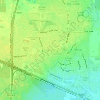
Name: Topografische Karte Fairfield, Höhe, Relief.
Ort: Fairfield, Harris County, Texas, United States (29.98539 -95.77149 30.02539 -95.73149)
Durchschnittliche Höhe: 56 m
Minimale Höhe: 45 m
Maximale Höhe: 62 m
Spenden
Rüste dich für dein nächstes Abenteuer:
Als Amazon-Partner verdient diese Website an qualifizierten Käufen, ohne zusätzliche Kosten für Sie.
Andere topografische Karten
Klicken Sie auf eine Karte, um ihre Topografie, ihre Höhe und ihr Relief anzuzeigen.
Paul D. Rushing Park & Chain of Lakes
United States > Texas > Harris County
Durchschnittliche Höhe: 49 m
Spenden
Rüste dich für dein nächstes Abenteuer:
Als Amazon-Partner verdient diese Website an qualifizierten Käufen, ohne zusätzliche Kosten für Sie.
original boundary of City of Houston
United States > Texas > Harris County > Houston
Durchschnittliche Höhe: 16 m
Spenden
Rüste dich für dein nächstes Abenteuer:
Als Amazon-Partner verdient diese Website an qualifizierten Käufen, ohne zusätzliche Kosten für Sie.
Addicks Reservoir
United States > Texas > Harris County > Houston
Addicks Reservoir is formed by a rolled earthen dam 61,666 feet (18,796 m) long and above the streambed. A 12-foot-wide (3.7 m) gravel road extends along the top of the dam. The top of the dam has a maximum elevation of 121 feet (37 m) above the NAVD 1988 and is almost 50 feet high in points. The maximum…
Durchschnittliche Höhe: 31 m
Spenden
Rüste dich für dein nächstes Abenteuer:
Als Amazon-Partner verdient diese Website an qualifizierten Käufen, ohne zusätzliche Kosten für Sie.
Spring Valley
United States > Texas > Harris County
In 1936 state highway maps indicated a cemetery and a church. Initially the settlement consisted of one and one-half square miles.Spring Valley, once known as Lusk, is at the intersection of Farm roads 2416 and 2113, fourteen miles southwest of Waco in southwestern McLennan County. A post office, called Lusk…
Durchschnittliche Höhe: 25 m
Spenden
Rüste dich für dein nächstes Abenteuer:
Als Amazon-Partner verdient diese Website an qualifizierten Käufen, ohne zusätzliche Kosten für Sie.
Spenden
Rüste dich für dein nächstes Abenteuer:
Als Amazon-Partner verdient diese Website an qualifizierten Käufen, ohne zusätzliche Kosten für Sie.