
Topografische Karte Overland Park
Interaktive Karte
Klicken Sie auf die Karte, um die Höhe anzuzeigen.
Über diese Karte
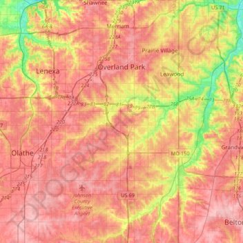
Name: Topografische Karte Overland Park, Höhe, Relief.
Ort: Overland Park, Johnson County, Kansas, United States (38.78900 -94.76107 39.04407 -94.60767)
Durchschnittliche Höhe: 300 m
Minimale Höhe: 227 m
Maximale Höhe: 343 m
Andere topografische Karten
Klicken Sie auf eine Karte, um ihre Topografie, ihre Höhe und ihr Relief anzuzeigen.
Lenexa
United States > Kansas > Johnson County
Lenexa, Johnson County, Kansas, United States
Durchschnittliche Höhe: 301 m
Fairway
United States > Kansas > Johnson County
Fairway, Johnson County, Kansas, United States
Durchschnittliche Höhe: 290 m
Lenexa
United States > Kansas > Johnson County > Lenexa
Lenexa, Johnson County, Kansas, 66219, United States
Durchschnittliche Höhe: 290 m
Leawood
United States > Kansas > Johnson County
Leawood, Johnson County, Kansas, United States
Durchschnittliche Höhe: 289 m
Overland Park
United States > Kansas > Johnson County > Overland Park
Overland Park, Johnson County, Kansas, 66204, United States
Durchschnittliche Höhe: 288 m
Prairie Village
United States > Kansas > Johnson County
Prairie Village, Johnson County, Kansas, United States
Durchschnittliche Höhe: 300 m
Olathe
United States > Kansas > Johnson County > Olathe
Olathe, Johnson County, Kansas, 66061, United States
Durchschnittliche Höhe: 302 m
Olathe
United States > Kansas > Johnson County
Olathe, Johnson County, Kansas, United States
Durchschnittliche Höhe: 309 m