
Topografische Karte Saint-Étienne-les-Bains
Interaktive Karte
Klicken Sie auf die Karte, um die Höhe anzuzeigen.
Über diese Karte
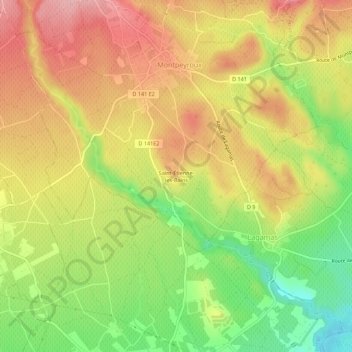
Name: Topografische Karte Saint-Étienne-les-Bains, Höhe, Relief.
Durchschnittliche Höhe: 115 m
Minimale Höhe: 37 m
Maximale Höhe: 180 m
Andere topografische Karten
Klicken Sie auf eine Karte, um ihre Topografie, ihre Höhe und ihr Relief anzuzeigen.
Le Barry
France > Occitanie > Hérault > Montpeyroux
Le Barry, Montpeyroux, Lodève, Hérault, Occitanie, France métropolitaine, 34150, France
Durchschnittliche Höhe: 211 m
Le Castellas
France > Occitanie > Hérault > Montpeyroux > Le Barry
Le Castellas, Le Barry, Montpeyroux, Lodève, Hérault, Occitanie, France métropolitaine, 34150, France
Durchschnittliche Höhe: 218 m