
Topografische Karte Blakeslee
Interaktive Karte
Klicken Sie auf die Karte, um die Höhe anzuzeigen.
Über diese Karte
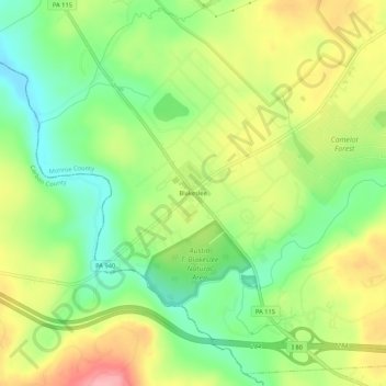
Name: Topografische Karte Blakeslee, Höhe, Relief.
Durchschnittliche Höhe: 504 m
Minimale Höhe: 448 m
Maximale Höhe: 575 m
Andere topografische Karten
Klicken Sie auf eine Karte, um ihre Topografie, ihre Höhe und ihr Relief anzuzeigen.
Kalahari Indoor Waterpark
United States > Pennsylvania > Monroe County > Tobyhanna Township
Kalahari Indoor Waterpark, Kalahari Boulevard, Tobyhanna Township, Monroe County, Pennsylvania, 18346, United States
Durchschnittliche Höhe: 553 m
Pocono Lake
United States > Pennsylvania > Monroe County > Tobyhanna Township > Pocono Pines
Pocono Lake, Pocono Pines, Tobyhanna Township, Monroe County, Pennsylvania, 18347, United States
Durchschnittliche Höhe: 537 m
Lake Naomi
United States > Pennsylvania > Monroe County > Tobyhanna Township > Pocono Pines > Pocono Lake
Lake Naomi, Pocono Lake, Pocono Pines, Tobyhanna Township, Monroe County, Pennsylvania, 18347, United States
Durchschnittliche Höhe: 549 m
Pocono Summit
United States > Pennsylvania > Monroe County > Tobyhanna Township
Pocono Summit, Tobyhanna Township, Monroe County, Pennsylvania, 18346, United States
Durchschnittliche Höhe: 547 m
Pocono Pines
United States > Pennsylvania > Monroe County > Tobyhanna Township
Pocono Pines, Tobyhanna Township, Monroe County, Pennsylvania, 18350, United States
Durchschnittliche Höhe: 556 m
Pinecrest Lake
United States > Pennsylvania > Monroe County > Tobyhanna Township
Pinecrest Lake, Tobyhanna Township, Monroe County, Pennsylvania, United States
Durchschnittliche Höhe: 556 m
Camelot Forest
United States > Pennsylvania > Monroe County > Tobyhanna Township
Camelot Forest, Tobyhanna Township, Monroe County, Pennsylvania, United States
Durchschnittliche Höhe: 514 m