
Topografische Karte Morehead
Interaktive Karte
Klicken Sie auf die Karte, um die Höhe anzuzeigen.
Über diese Karte
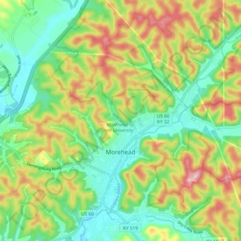
Name: Topografische Karte Morehead, Höhe, Relief.
Ort: Morehead, Rowan County, Kentucky, 40351, United States (38.16309 -83.49611 38.22257 -83.40844)
Durchschnittliche Höhe: 287 m
Minimale Höhe: 207 m
Maximale Höhe: 413 m
Morehead is in the foothills of the Appalachian Mountains. The topography of the area represents a mixture of the Highland Rim and the western border of the Eastern Kentucky Coalfield. The highest elevation in the county is Limestone Knob (1435 ft), situated approximately 3 miles southwest of Morehead. The elevation of the city is 748 ft.