
Topografische Karte Hartford County
Interaktive Karte
Klicken Sie auf die Karte, um die Höhe anzuzeigen.
Über diese Karte
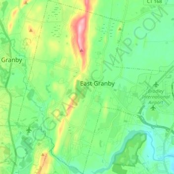
Name: Topografische Karte Hartford County, Höhe, Relief.
Ort: East Granby, Hartford County, Connecticut, 06026, USA (41.89227 -72.78582 41.98598 -72.68763)
Durchschnittliche Höhe: 62 m
Minimale Höhe: 4 m
Maximale Höhe: 212 m
Andere topografische Karten
Klicken Sie auf eine Karte, um ihre Topografie, ihre Höhe und ihr Relief anzuzeigen.
Major Island
Major Island, New London County, Connecticut, USA
Durchschnittliche Höhe: 16 m
Storrs
USA > Connecticut > Storrs
Storrs, Tolland County, Connecticut, USA
Durchschnittliche Höhe: 165 m