
Topografische Karte Icho Cruz
Interaktive Karte
Klicken Sie auf die Karte, um die Höhe anzuzeigen.
Über diese Karte
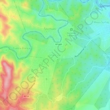
Name: Topografische Karte Icho Cruz, Höhe, Relief.
Durchschnittliche Höhe: 764 m
Minimale Höhe: 683 m
Maximale Höhe: 891 m
Andere topografische Karten
Klicken Sie auf eine Karte, um ihre Topografie, ihre Höhe und ihr Relief anzuzeigen.
Los Gigantes
Argentina > Córdoba > Pedanía Santiago
Los Gigantes, Pedanía Santiago, Departamento Punilla, Córdoba, X5166, Argentina
Durchschnittliche Höhe: 1.696 m
Copina
Argentina > Córdoba > Pedanía Santiago
Copina, Pedanía Santiago, Departamento Punilla, Córdoba, X5166, Argentina
Durchschnittliche Höhe: 1.484 m