
Topografische Karte Mentone
Interaktive Karte
Klicken Sie auf die Karte, um die Höhe anzuzeigen.
Über diese Karte
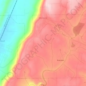
Name: Topografische Karte Mentone, Höhe, Relief.
Ort: Mentone, DeKalb County, Alabama, 35984, United States (34.55130 -85.61363 34.58458 -85.56558)
Durchschnittliche Höhe: 471 m
Minimale Höhe: 307 m
Maximale Höhe: 566 m
Mentone is located in eastern DeKalb County at 34°34′20″N 85°34′49″W / 34.57222°N 85.58028°W / 34.57222; -85.58028 (34.572360, -85.580283). It is bordered to the west by the town of Valley Head. The center of town is located on the crest of Lookout Mountain at an elevation of 1,736 feet (529 m). The western border of the town, with Valley Head, follows the western slopes of the mountain. Extending south from the town center is the mountain's ridgecrest that rises to an elevation of 1,785 feet (544 m) within the town limits. The West Fork of the Little River crosses the eastern portion of the town at an elevation less than 100 feet (30 m) below the ridgecrest.
Andere topografische Karten
Klicken Sie auf eine Karte, um ihre Topografie, ihre Höhe und ihr Relief anzuzeigen.
Fort Payne
United States > Alabama > DeKalb County
Fort Payne, DeKalb County, Alabama, 35967, United States
Durchschnittliche Höhe: 369 m
Henagar
United States > Alabama > DeKalb County
Henagar, DeKalb County, Alabama, 35978, United States
Durchschnittliche Höhe: 436 m
Grove Oak
United States > Alabama > DeKalb County
Grove Oak, DeKalb County, Alabama, 35975, United States
Durchschnittliche Höhe: 344 m
Hammondville
United States > Alabama > DeKalb County
Hammondville, DeKalb County, Alabama, United States
Durchschnittliche Höhe: 362 m
Shiloh
United States > Alabama > DeKalb County
Shiloh, DeKalb County, Alabama, United States
Durchschnittliche Höhe: 376 m
Lakeview
United States > Alabama > DeKalb County
Lakeview, DeKalb County, Alabama, United States
Durchschnittliche Höhe: 344 m
Valley Head
United States > Alabama > DeKalb County
Valley Head, DeKalb County, Alabama, United States
Durchschnittliche Höhe: 410 m
Collinsville
United States > Alabama > DeKalb County
Collinsville, DeKalb County, Alabama, 35961, United States
Durchschnittliche Höhe: 285 m
Rainsville
United States > Alabama > DeKalb County
Rainsville, DeKalb County, Alabama, 35986, United States
Durchschnittliche Höhe: 380 m
Crossville
United States > Alabama > DeKalb County
Crossville, DeKalb County, Alabama, United States
Durchschnittliche Höhe: 337 m
Powell
United States > Alabama > DeKalb County
Powell, DeKalb County, Alabama, United States
Durchschnittliche Höhe: 380 m
Mentone
United States > Alabama > DeKalb County
Mentone, DeKalb County, Alabama, 35984, United States
Durchschnittliche Höhe: 470 m
Geraldine
United States > Alabama > DeKalb County
Geraldine, DeKalb County, Alabama, 35974, United States
Durchschnittliche Höhe: 349 m
Fyffe
United States > Alabama > DeKalb County
Fyffe, DeKalb County, Alabama, 35971, United States
Durchschnittliche Höhe: 376 m
Pine Ridge
United States > Alabama > DeKalb County
Pine Ridge, DeKalb County, Alabama, United States
Durchschnittliche Höhe: 312 m
Desoto State Park
United States > Alabama > DeKalb County > Fort Payne
Desoto State Park, Fort Payne, DeKalb County, Alabama, United States
Durchschnittliche Höhe: 454 m
Minvale
United States > Alabama > DeKalb County > Fort Payne > Minvale
Minvale, Fort Payne, DeKalb County, Alabama, 35967, United States
Durchschnittliche Höhe: 322 m
Little River Canyon National Preserve
United States > Alabama > DeKalb County > Fort Payne
Little River Canyon National Preserve, Fort Payne, DeKalb County, Alabama, United States
Durchschnittliche Höhe: 328 m
Collinsville
United States > Alabama > DeKalb County > Collinsville
Collinsville, DeKalb County, Alabama, 35961, United States
Durchschnittliche Höhe: 285 m
Ider
United States > Alabama > DeKalb County
Ider, DeKalb County, Alabama, United States
Durchschnittliche Höhe: 467 m
Fort Payne
United States > Alabama > DeKalb County > Fort Payne
Fort Payne, DeKalb County, Alabama, 35967, United States
Durchschnittliche Höhe: 350 m
Red Hill
United States > Alabama > DeKalb County
Red Hill, DeKalb County, Alabama, United States
Durchschnittliche Höhe: 255 m
Sylvania
United States > Alabama > DeKalb County
Sylvania, DeKalb County, Alabama, 35988, United States
Durchschnittliche Höhe: 405 m