
Topografische Karte Gurteen
Interaktive Karte
Klicken Sie auf die Karte, um die Höhe anzuzeigen.
Über diese Karte
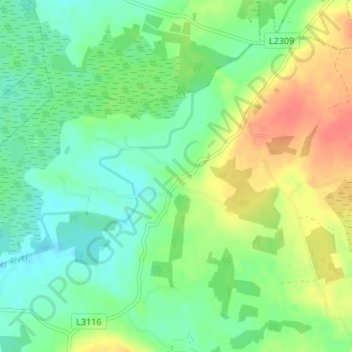
Name: Topografische Karte Gurteen, Höhe, Relief.
Durchschnittliche Höhe: 89 m
Minimale Höhe: 70 m
Maximale Höhe: 120 m
Andere topografische Karten
Klicken Sie auf eine Karte, um ihre Topografie, ihre Höhe und ihr Relief anzuzeigen.
Drought
Drought, Kilreekill ED, Loughrea Municipal District, County Galway, Connacht, Ireland
Durchschnittliche Höhe: 78 m
Costelloe
Costelloe, Conamara Municipal District, County Galway, Connacht, H91 A2T6, Ireland
Durchschnittliche Höhe: 12 m
Furbo
Furbo, County Galway, Connacht, H91 KX27, Ireland
Durchschnittliche Höhe: 16 m
Headford
Headford, Headford ED, Tuam Municipal District, County Galway, Connacht, Ireland
Durchschnittliche Höhe: 20 m
Curtaun
Curtaun, Beagh ED, Loughrea Municipal District, County Galway, Connacht, Ireland
Durchschnittliche Höhe: 27 m
Glassilaun Beach
Glassilaun Beach, Cushkillary ED, Conamara Municipal District, County Galway, Connacht, Ireland
Durchschnittliche Höhe: 11 m
Eyrephort
Eyrephort, Clifden ED, Conamara Municipal District, County Galway, Connacht, Ireland
Durchschnittliche Höhe: 6 m
Mullaghmore East
Mullaghmore East, Cooloo ED, Ballinasloe Municipal District, County Galway, Connacht, Ireland
Durchschnittliche Höhe: 79 m
Loughrea Municipal District
Loughrea Municipal District, County Galway, Connacht, Ireland
Durchschnittliche Höhe: 69 m
Kilconnell
Kilconnell, Kilconnell ED, Ballinasloe Municipal District, County Galway, Connacht, Ireland
Durchschnittliche Höhe: 92 m
Cappataggle
Cappataggle, Killallaghtan ED, Ballinasloe Municipal District, County Galway, Connacht, Ireland
Durchschnittliche Höhe: 122 m
Tuam
Tuam, Tuam Municipal District, County Galway, Connacht, Ireland
Durchschnittliche Höhe: 40 m
Kiltullagh North
Kiltullagh North, Kiltullagh ED, Loughrea Municipal District, County Galway, Connacht, Ireland
Durchschnittliche Höhe: 46 m
Cappaghnagapple
Cappaghnagapple, Cloonbur ED, Conamara Municipal District, County Galway, Connacht, Ireland
Durchschnittliche Höhe: 72 m
Claregalway
Claregalway, Athenry-Oranmore Municipal District, County Galway, Connacht, H91 F5EH, Ireland
Durchschnittliche Höhe: 16 m
Derryclare
Derryclare, Conamara Municipal District, County Galway, Connacht, H91 TP63, Ireland
Durchschnittliche Höhe: 279 m
Ballinasloe Municipal District
Ballinasloe Municipal District, County Galway, Connacht, Ireland
Durchschnittliche Höhe: 66 m
Ballybrit
Ireland > County Galway > Galway
Ballybrit, Galway, County Galway, Connacht, Ireland
Durchschnittliche Höhe: 39 m
Carrowroe South
Carrowroe South, An Crompán, Conamara Municipal District, County Galway, Connacht, Ireland
Durchschnittliche Höhe: 11 m
Killeany
Killeany, Inishmore, Conamara Municipal District, County Galway, Connacht, H91 P266, Ireland
Durchschnittliche Höhe: 23 m
Gortnarup
Gortnarup, Cloonbur ED, Conamara Municipal District, County Galway, Connacht, Ireland
Durchschnittliche Höhe: 114 m
Athenry-Oranmore Municipal District
Athenry-Oranmore Municipal District, County Galway, Connacht, Ireland
Durchschnittliche Höhe: 42 m
Carrowroe
Carrowroe, Kilmeen ED, Loughrea Municipal District, County Galway, Connacht, Ireland
Durchschnittliche Höhe: 76 m
Fairhill
Fairhill, Mounthazel ED, Ballinasloe Municipal District, County Galway, Connacht, Ireland
Durchschnittliche Höhe: 87 m
Galway Bay
Galway Bay, County Galway, Connacht, Ireland
Durchschnittliche Höhe: 35 m
Newforest
Newforest, Curraghmore ED, Ballinasloe Municipal District, County Galway, Connacht, Ireland
Durchschnittliche Höhe: 82 m
Kylemore
Kylemore, Loughrea Municipal District, County Galway, Connacht, Ireland
Durchschnittliche Höhe: 45 m
Capira
Capira, Portumna ED, Loughrea Municipal District, County Galway, Connacht, Ireland
Durchschnittliche Höhe: 53 m