
Topografische Karte Tunja
Interaktive Karte
Klicken Sie auf die Karte, um die Höhe anzuzeigen.
Tunja
Tunja has a population of 172,548 inhabitants according to the 2018 Census. 0.1% of the city is indigenous, 0.4% is black, and 99.5% is white and Mestizo. It is located in central Colombia. The city centre is at an elevation of 2,820 metres (9,250 ft) above sea level.
Über diese Karte
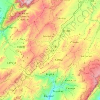
Name: Topografische Karte Tunja, Höhe, Relief.
Durchschnittliche Höhe: 2.824 m
Minimale Höhe: 2.053 m
Maximale Höhe: 3.790 m