
Topografische Karte Virgin
Interaktive Karte
Klicken Sie auf die Karte, um die Höhe anzuzeigen.
Über diese Karte
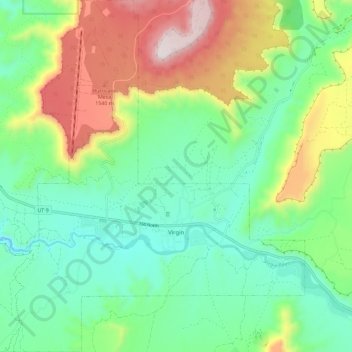
Name: Topografische Karte Virgin, Höhe, Relief.
Ort: Virgin, Washington County, Utah, United States (37.17063 -113.25585 37.26243 -113.14567)
Durchschnittliche Höhe: 1.251 m
Minimale Höhe: 1.003 m
Maximale Höhe: 1.758 m
Virgin is a town in Washington County, Utah, United States. The population was 596 at the 2010 census. The first settlement at Virgin was made in 1858. It is located along the Virgin River (for which it is named), and not far from Zion National Park. The elevation is 3,606 feet (1,099 m). It lies on State Route 9.