
Topografische Karte Nelson
Klicken Sie auf die Karte, um die Höhe anzuzeigen.
Über diese Karte
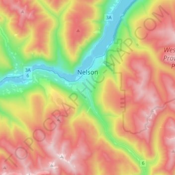
Name: Topografische Karte Nelson, Höhe, Relief.
Durchschnittliche Höhe: 1.325 m
Minimale Höhe: 526 m
Maximale Höhe: 2.190 m
Andere topografische Karten
Klicken Sie auf eine Karte, um ihre Topografie, ihre Höhe und ihr Relief anzuzeigen.
Burton
Canada > British Columbia > Regional District of Central Kootenay > Area K (The Arrow Lakes)
Durchschnittliche Höhe: 578 m
Nelway
Canada > British Columbia > Regional District of Central Kootenay > Area G (Salmo Valley)
Durchschnittliche Höhe: 924 m
Procter
Canada > British Columbia > Regional District of Central Kootenay > Area E (Balfour/Cottonwood Lake)
Durchschnittliche Höhe: 715 m
Kingsgate
Canada > British Columbia > Regional District of Central Kootenay > Area B (Goat River Valley)
Durchschnittliche Höhe: 979 m
Rockslide Lake
Canada > British Columbia > Regional District of Central Kootenay > Area F (Kokanee Range)
Durchschnittliche Höhe: 1.605 m
Gibson Creek
Canada > British Columbia > Regional District of Central Kootenay > Area I (Sentinel Mountain)
Durchschnittliche Höhe: 778 m
Crawford Bay
Canada > British Columbia > Regional District of Central Kootenay > Area A (Wynndel/Crawford Bay/Riondel)
Durchschnittliche Höhe: 667 m
Vallican
Canada > British Columbia > Regional District of Central Kootenay > Area H (The Slocan Valley)
Durchschnittliche Höhe: 821 m
Bentz Peak
Canada > British Columbia > Regional District of Central Kootenay > Area J (Lower Arrow/Columbia)
Durchschnittliche Höhe: 2.037 m
Ainsworth Hot Springs
Canada > British Columbia > Regional District of Central Kootenay > Area D (Lardeau Valley/Duncan Lake)
Durchschnittliche Höhe: 741 m
Goat River
Canada > British Columbia > Regional District of Central Kootenay > Area B (Goat River Valley)
Durchschnittliche Höhe: 1.713 m
Silent Pass
Canada > British Columbia > Regional District of Central Kootenay > Area D (Lardeau Valley/Duncan Lake)
Durchschnittliche Höhe: 2.100 m
Cooper Creek
Canada > British Columbia > Regional District of Central Kootenay > Area D (Lardeau Valley/Duncan Lake)
Durchschnittliche Höhe: 1.573 m
Keen Creek
Canada > British Columbia > Regional District of Central Kootenay > Area D (Lardeau Valley/Duncan Lake)
Durchschnittliche Höhe: 976 m
Ymir
Canada > British Columbia > Regional District of Central Kootenay > Area G (Salmo Valley)
Durchschnittliche Höhe: 967 m
Burton (Trout) Creek
Canada > British Columbia > Regional District of Central Kootenay > Area K (The Arrow Lakes)
Durchschnittliche Höhe: 1.659 m
Passmore
Canada > British Columbia > Regional District of Central Kootenay > Area H (The Slocan Valley)
Durchschnittliche Höhe: 819 m
Winlaw
Canada > British Columbia > Regional District of Central Kootenay > Area H (The Slocan Valley)
Durchschnittliche Höhe: 694 m
Shoreacres
Canada > British Columbia > Regional District of Central Kootenay > Area I (Sentinel Mountain)
Durchschnittliche Höhe: 632 m
Krestova
Canada > British Columbia > Regional District of Central Kootenay > Area H (The Slocan Valley)
Durchschnittliche Höhe: 640 m
Blewett
Canada > British Columbia > Regional District of Central Kootenay > Area E (Balfour/Cottonwood Lake) > Blewett
Durchschnittliche Höhe: 837 m
Goatfell
Canada > British Columbia > Regional District of Central Kootenay > Area B
Durchschnittliche Höhe: 975 m
Kokanee Creek
Canada > British Columbia > Regional District of Central Kootenay > Area E (Balfour/Cottonwood Lake)
Durchschnittliche Höhe: 2.022 m
Castlegar
Canada > British Columbia > Regional District of Central Kootenay > Castlegar
Durchschnittliche Höhe: 1.207 m
Playmor Junction
Canada > British Columbia > Regional District of Central Kootenay > Area H (The Slocan Valley) > South Slocan
Durchschnittliche Höhe: 578 m
Kitchener
Canada > British Columbia > Regional District of Central Kootenay > Area B (Goat River Valley)
Durchschnittliche Höhe: 925 m
Pass Creek
Canada > British Columbia > Regional District of Central Kootenay > Area I (Sentinel Mountain)
Durchschnittliche Höhe: 751 m
Kootenay Canal
Canada > British Columbia > Regional District of Central Kootenay > Nelson
Durchschnittliche Höhe: 663 m
Boswell
Canada > British Columbia > Regional District of Central Kootenay > Area A (Wynndel/Crawford Bay/Riondel)
Durchschnittliche Höhe: 779 m
Stoney Creek
Canada > British Columbia > Regional District of Central Kootenay > Area K (The Arrow Lakes)
Durchschnittliche Höhe: 1.295 m
Taghum
Canada > British Columbia > Regional District of Central Kootenay > Area F (Kokanee Range)
Durchschnittliche Höhe: 745 m
Poplar Creek
Canada > British Columbia > Regional District of Central Kootenay > Area D (Lardeau Valley/Duncan Lake)
Durchschnittliche Höhe: 1.732 m
Granite
Canada > British Columbia > Regional District of Central Kootenay > Area E (Balfour/Cottonwood Lake) > Blewett
Durchschnittliche Höhe: 772 m
Mount Nemo
Canada > British Columbia > Regional District of Central Kootenay > Area D (Lardeau Valley/Duncan Lake)
Durchschnittliche Höhe: 2.283 m
Salmo
Canada > British Columbia > Regional District of Central Kootenay
Durchschnittliche Höhe: 1.049 m
South Slocan
Canada > British Columbia > Regional District of Central Kootenay > Area H (The Slocan Valley)
Durchschnittliche Höhe: 578 m
Sandon
Canada > British Columbia > Regional District of Central Kootenay > Area H (The Slocan Valley)
Durchschnittliche Höhe: 1.529 m
Riondel
Canada > British Columbia > Regional District of Central Kootenay > Area A (Wynndel/Crawford Bay/Riondel)
Durchschnittliche Höhe: 675 m
Harrop
Canada > British Columbia > Regional District of Central Kootenay > Area E (Balfour/Cottonwood Lake)
Durchschnittliche Höhe: 675 m
Raspberry
Canada > British Columbia > Regional District of Central Kootenay > Area J (Lower Arrow/Columbia)
Durchschnittliche Höhe: 651 m
Butters Lake
Canada > British Columbia > Regional District of Central Kootenay > Area D (Lardeau Valley/Duncan Lake)
Durchschnittliche Höhe: 2.133 m
Crescent Valley
Canada > British Columbia > Regional District of Central Kootenay > Area H (The Slocan Valley)
Durchschnittliche Höhe: 602 m
Mazinaw Mountain
Canada > British Columbia > Regional District of Central Kootenay > Area D (Lardeau Valley/Duncan Lake)
Durchschnittliche Höhe: 2.578 m
Lemon Creek
Canada > British Columbia > Regional District of Central Kootenay > Area H (The Slocan Valley)
Durchschnittliche Höhe: 1.527 m
Columbia River
Canada > British Columbia > Regional District of Central Kootenay > Castlegar
Durchschnittliche Höhe: 598 m
Balfour
Canada > British Columbia > Regional District of Central Kootenay > Area E (Balfour/Cottonwood Lake)
Durchschnittliche Höhe: 673 m
Erickson
Canada > British Columbia > Regional District of Central Kootenay > Area B (Goat River Valley)
Durchschnittliche Höhe: 680 m
Hall Creek
Canada > British Columbia > Regional District of Central Kootenay > Area G (Salmo Valley)
Durchschnittliche Höhe: 1.570 m
Procter
Canada > British Columbia > Regional District of Central Kootenay > Area E (Balfour/Cottonwood Lake)
Durchschnittliche Höhe: 715 m
Commonwealth Mountain
Canada > British Columbia > Regional District of Central Kootenay > Area G (Salmo Valley)
Durchschnittliche Höhe: 1.871 m