
Topografische Karte Denali
Interaktive Karte
Klicken Sie auf die Karte, um die Höhe anzuzeigen.
Über diese Karte
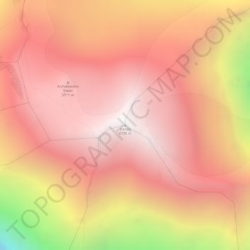
Name: Topografische Karte Denali, Höhe, Relief.
Ort: Denali, Alaska, United States (63.06907 -151.00629 63.06917 -151.00619)
Durchschnittliche Höhe: 5.546 m
Minimale Höhe: 4.151 m
Maximale Höhe: 6.170 m
Denali (/dəˈnɑːli/; also known as Mount McKinley, its former official name) is the highest mountain peak in North America, with a summit elevation of 20,310 feet (6,190 m) above sea level. With a topographic prominence of 20,194 feet (6,155 m) and a topographic isolation of 4,621.1 miles (7,436.9 km), Denali is the third most prominent and third most isolated peak on Earth, after Mount Everest and Aconcagua. Located in the Alaska Range in the interior of the U.S. state of Alaska, Denali is the centerpiece of Denali National Park and Preserve.
Andere topografische Karten
Klicken Sie auf eine Karte, um ihre Topografie, ihre Höhe und ihr Relief anzuzeigen.
Healy
United States > Alaska > Denali
Healy, Denali, Alaska, 99743, United States
Durchschnittliche Höhe: 484 m
Cantwell
United States > Alaska > Denali
Cantwell, Denali, Alaska, 99729, United States
Durchschnittliche Höhe: 1.104 m
Red Mountain
United States > Alaska > Denali
Red Mountain, Denali, Alaska, United States
Durchschnittliche Höhe: 1.708 m