
Topografische Karte Les Trois Châteaux
Interaktive Karte
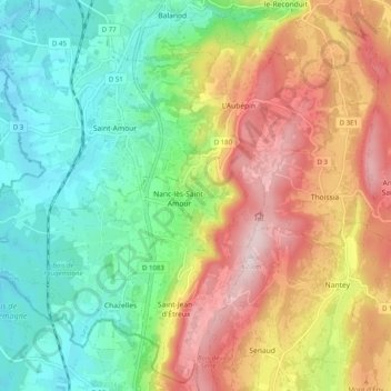
Klicken Sie auf die Karte, um die Höhe anzuzeigen.
Über diese Karte
Name: Topografische Karte Les Trois Châteaux, Höhe, Relief.
Durchschnittliche Höhe: 372 m
Minimale Höhe: 203 m
Maximale Höhe: 616 m
Andere topografische Karten
Klicken Sie auf eine Karte, um ihre Topografie, ihre Höhe und ihr Relief anzuzeigen.
Saint-Jean-d'Étreux
France > Bourgogne-Franche-Comté > Jura > Les Trois-Châteaux
Saint-Jean-d'Étreux, Les Trois-Châteaux, Lons-le-Saunier, Jura, Bourgogne-Franche-Comté, France métropolitaine, 39160, France
Durchschnittliche Höhe: 417 m
L'Aubépin
France > Bourgogne-Franche-Comté > Jura > Les Trois-Châteaux
L'Aubépin, Les Trois-Châteaux, Lons-le-Saunier, Jura, Bourgogne-Franche-Comté, France métropolitaine, 39160, France
Durchschnittliche Höhe: 481 m
Chazelles
France > Bourgogne-Franche-Comté > Jura > Les Trois-Châteaux
Chazelles, Les Trois-Châteaux, Lons-le-Saunier, Jura, Bourgogne-Franche-Comté, France métropolitaine, 39160, France
Durchschnittliche Höhe: 269 m
Cessia
France > Bourgogne-Franche-Comté > Jura > Les Trois-Châteaux
Cessia, Saint-Jean-d'Étreux, Les Trois-Châteaux, Lons-le-Saunier, Jura, Bourgogne-Franche-Comté, France métropolitaine, 39160, France
Durchschnittliche Höhe: 397 m
Nanc-lès-Saint-Amour
France > Bourgogne-Franche-Comté > Jura > Les Trois-Châteaux
Nanc-lès-Saint-Amour, Les Trois-Châteaux, Lons-le-Saunier, Jura, Bourgogne-Franche-Comté, France métropolitaine, 39160, France
Durchschnittliche Höhe: 334 m