
Topografische Karte Ibagué
Interaktive Karte
Klicken Sie auf die Karte, um die Höhe anzuzeigen.
Über diese Karte
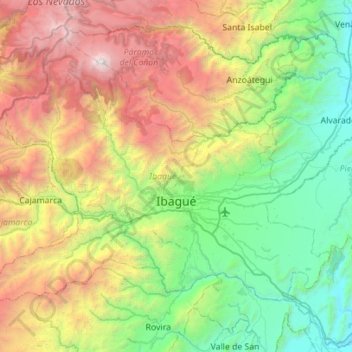
Name: Topografische Karte Ibagué, Höhe, Relief.
Ort: Ibagué, Centro, Tolima, Colombia (4.25786 -75.52470 4.69933 -74.96675)
Durchschnittliche Höhe: 1.907 m
Minimale Höhe: 308 m
Maximale Höhe: 5.213 m
Ibagué features a tropical rainforest climate under the Köppen climate classification, albeit a relatively cooler version of the climate due to the high altitude. Although the city does experience noticeably drier conditions during and around the months of January and July, the city has no true dry season month, as all twelve months see on average more than 60 mm (2.4 in) of rain. As is commonplace in areas with this climate, temperatures are relatively consistent throughout the course of the year in Ibagué, with average high temperatures of about 28 °C or 82.4 °F and average low temperatures of about 18 °C or 64.4 °F. On average Ibagué sees 1,700 mm (66.9 in) of rain annually.
Andere topografische Karten
Klicken Sie auf eine Karte, um ihre Topografie, ihre Höhe und ihr Relief anzuzeigen.
Roncesvalles
Colombia > Tolima > Roncesvalles
Roncesvalles, Sur, Tolima, Colombia
Durchschnittliche Höhe: 2.842 m
Coello Cocora
Colombia > Tolima > Ibagué > Coello Cocora
Coello Cocora, Ibagué, Centro, Tolima, Colombia
Durchschnittliche Höhe: 1.381 m
Los naranjos
Colombia > Tolima > Los naranjos
Los naranjos, Ibagué, Tolima, Colombia
Durchschnittliche Höhe: 1.783 m
La Nueva Aurora
Colombia > Tolima > La Nueva Aurora
La Nueva Aurora, Ataco, Tolima, Colombia
Durchschnittliche Höhe: 1.345 m
Vega Larga
Colombia > Tolima > Vega Larga
Vega Larga, Ataco, Tolima, Colombia
Durchschnittliche Höhe: 1.493 m
Cordillera Central
Cordillera Central, Planadas, Sur, Tolima, RAP Eje Cafetero, Colombia
Durchschnittliche Höhe: 3.706 m
Nevado del Tolima
Nevado del Tolima, Anzoátegui, Tolima, Colombia
Durchschnittliche Höhe: 4.657 m