
Topografische Karte Ohrigstad
Interaktive Karte
Klicken Sie auf die Karte, um die Höhe anzuzeigen.
Über diese Karte
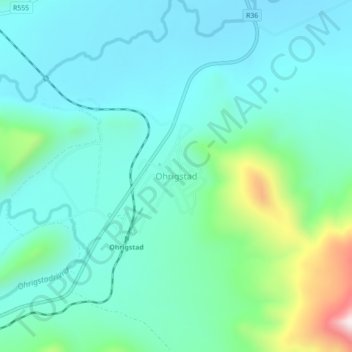
Name: Topografische Karte Ohrigstad, Höhe, Relief.
Durchschnittliche Höhe: 1.156 m
Minimale Höhe: 1.039 m
Maximale Höhe: 1.623 m
Andere topografische Karten
Klicken Sie auf eine Karte, um ihre Topografie, ihre Höhe und ihr Relief anzuzeigen.
Bothashoek
South Africa > Limpopo > Sekhukhune District Municipality > Greater Tubatse Local Municipality
Bothashoek, Greater Tubatse Local Municipality, Sekhukhune District Municipality, Limpopo, South Africa
Durchschnittliche Höhe: 821 m
Burgersfort
South Africa > Limpopo > Sekhukhune District Municipality > Greater Tubatse Local Municipality
Burgersfort, Greater Tubatse Local Municipality, Sekhukhune District Municipality, Limpopo, 1105, South Africa
Durchschnittliche Höhe: 810 m
Steelpoort
South Africa > Limpopo > Sekhukhune District Municipality > Greater Tubatse Local Municipality
Steelpoort, Greater Tubatse Local Municipality, Sekhukhune District Municipality, Limpopo, South Africa
Durchschnittliche Höhe: 1.062 m