
Topografische Karte La Rouge
Interaktive Karte
Klicken Sie auf die Karte, um die Höhe anzuzeigen.
Über diese Karte
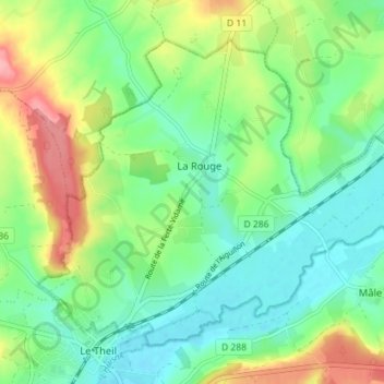
Name: Topografische Karte La Rouge, Höhe, Relief.
Durchschnittliche Höhe: 127 m
Minimale Höhe: 90 m
Maximale Höhe: 199 m
Andere topografische Karten
Klicken Sie auf eine Karte, um ihre Topografie, ihre Höhe und ihr Relief anzuzeigen.
Mâle
France > Normandie > Orne > Val-au-Perche
Mâle, Val-au-Perche, Mortagne-au-Perche, Orne, Normandie, France métropolitaine, 61260, France
Durchschnittliche Höhe: 149 m
La Taille
France > Normandie > Orne > Val-au-Perche
La Taille, Le Theil, Val-au-Perche, Mortagne-au-Perche, Orne, Normandie, France métropolitaine, 61260, France
Durchschnittliche Höhe: 123 m
Le Theil
France > Normandie > Orne > Val-au-Perche
Le Theil, Val-au-Perche, Mortagne-au-Perche, Orne, Normandie, France métropolitaine, 61260, France
Durchschnittliche Höhe: 141 m
Beaulieu
France > Normandie > Orne > Val-au-Perche
Beaulieu, Saint-Agnan-sur-Erre, Val-au-Perche, Mortagne-au-Perche, Orne, Normandie, France métropolitaine, 61340, France
Durchschnittliche Höhe: 132 m
L'Hermitière
France > Normandie > Orne > Val-au-Perche
L'Hermitière, Val-au-Perche, Mortagne-au-Perche, Orne, Normandie, France métropolitaine, 61260, France
Durchschnittliche Höhe: 156 m
Gémages
France > Normandie > Orne > Val-au-Perche
Gémages, Val-au-Perche, Mortagne-au-Perche, Orne, Normandie, France métropolitaine, 61130, France
Durchschnittliche Höhe: 146 m
La Monnerie
France > Normandie > Orne > Val-au-Perche
La Monnerie, Gémages, Val-au-Perche, Mortagne-au-Perche, Orne, Normandie, France métropolitaine, 61130, France
Durchschnittliche Höhe: 137 m