
Topografische Karte Eskisehir
Interaktive Karte
Klicken Sie auf die Karte, um die Höhe anzuzeigen.
Über diese Karte
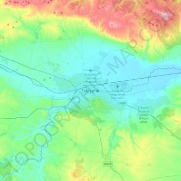
Name: Topografische Karte Eskisehir, Höhe, Relief.
Durchschnittliche Höhe: 949 m
Minimale Höhe: 775 m
Maximale Höhe: 1.517 m
Eskişehir has a cold semi-arid climate (BSk) under the Köppen climate classification, and a temperate continental climate (Dc) under the Trewartha climate classification. The city features cold, snowy winters and warm, dry summers. Rainfall occurs mostly during the spring and autumn. Due to Eskişehir's high altitude and its dry summers, nightly temperatures in the summer months are cool. Precipitation levels are low, but precipitation can be observed throughout the year.