
Topografische Karte Cabecera Municipal Villamaría
Interaktive Karte
Klicken Sie auf die Karte, um die Höhe anzuzeigen.
Über diese Karte
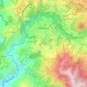
Name: Topografische Karte Cabecera Municipal Villamaría, Höhe, Relief.
Durchschnittliche Höhe: 1.950 m
Minimale Höhe: 1.583 m
Maximale Höhe: 2.411 m
Las variaciones altitudinales otorgan al municipio de Villamaría la posibilidad de tener tres pisos térmicos, identificados en microrregiones (zona alta o de páramo, zona media u hortofrutícula, zona baja cafetera), con un potencial productivo y turístico.
Andere topografische Karten
Klicken Sie auf eine Karte, um ihre Topografie, ihre Höhe und ihr Relief anzuzeigen.
Las Brisas
Colombia > Caldas > Villamaría
Las Brisas, Villamaría, Centrosur, Caldas, RAP del Agua y la Montaña, 176001, Colombia
Durchschnittliche Höhe: 2.038 m
Río Chinchiná
Colombia > Caldas > Villamaría
Río Chinchiná, Villamaría, Centrosur, Caldas, 170008, Colombia
Durchschnittliche Höhe: 1.966 m