
Topografische Karte Kokanee Creek Provincial Park
Interaktive Karte
Klicken Sie auf die Karte, um die Höhe anzuzeigen.
Über diese Karte
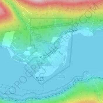
Name: Topografische Karte Kokanee Creek Provincial Park, Höhe, Relief.
Durchschnittliche Höhe: 617 m
Minimale Höhe: 527 m
Maximale Höhe: 944 m
Andere topografische Karten
Klicken Sie auf eine Karte, um ihre Topografie, ihre Höhe und ihr Relief anzuzeigen.
West Arm Provincial Park
Canada > British Columbia > Regional District of Central Kootenay > Area E (Balfour/Cottonwood Lake)
West Arm Provincial Park, Area E (Balfour/Cottonwood Lake), Regional District of Central Kootenay, British Columbia, Canada
Durchschnittliche Höhe: 1.449 m
Granite
Canada > British Columbia > Regional District of Central Kootenay > Area E (Balfour/Cottonwood Lake) > Blewett
Granite, Blewett, Area E (Balfour/Cottonwood Lake), Regional District of Central Kootenay, British Columbia, V1L 6X4, Canada
Durchschnittliche Höhe: 772 m
Ross-White Lady Lake Recreation Site
Canada > British Columbia > Regional District of Central Kootenay > Area E (Balfour/Cottonwood Lake)
Ross-White Lady Lake Recreation Site, Area E (Balfour/Cottonwood Lake), Regional District of Central Kootenay, British Columbia, Canada
Durchschnittliche Höhe: 1.858 m
Blewett
Canada > British Columbia > Regional District of Central Kootenay > Area E (Balfour/Cottonwood Lake) > Blewett
Blewett, Area E (Balfour/Cottonwood Lake), Regional District of Central Kootenay, British Columbia, V1L 6X4, Canada
Durchschnittliche Höhe: 837 m
Area E (Balfour/Cottonwood Lake)
Canada > British Columbia > Regional District of Central Kootenay > Area E (Balfour/Cottonwood Lake)
Area E (Balfour/Cottonwood Lake), Regional District of Central Kootenay, British Columbia, Canada
Durchschnittliche Höhe: 1.433 m
Kokanee Creek
Canada > British Columbia > Regional District of Central Kootenay > Area E (Balfour/Cottonwood Lake)
Kokanee Creek, Area E (Balfour/Cottonwood Lake), Regional District of Central Kootenay, British Columbia, Canada
Durchschnittliche Höhe: 2.022 m
Balfour
Canada > British Columbia > Regional District of Central Kootenay > Area E (Balfour/Cottonwood Lake)
Balfour, Area E (Balfour/Cottonwood Lake), Regional District of Central Kootenay, British Columbia, V0G 1C0, Canada
Durchschnittliche Höhe: 673 m