
Topografische Karte Tonatico
Interaktive Karte
Klicken Sie auf die Karte, um die Höhe anzuzeigen.
Über diese Karte
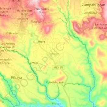
Name: Topografische Karte Tonatico, Höhe, Relief.
Ort: Tonatico, State of Mexico, Mexico (18.72033 -99.71230 18.83346 -99.57373)
Durchschnittliche Höhe: 1.617 m
Minimale Höhe: 1.201 m
Maximale Höhe: 2.105 m
Tonatico has several nearby mountains, including La Cruz and Tapachichi. The largest is La Puerta at 1,685 meters of elevation. The Salto de Zumpantitlán waterfall is nearby, along with the Tenancingo, San Geronimo and Taplalla rivers.