
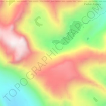
Topografische Karte Phantom Glacier
Interaktive Karte
Klicken Sie auf die Karte, um die Höhe anzuzeigen.
Über diese Karte
Name: Topografische Karte Phantom Glacier, Höhe, Relief.
Durchschnittliche Höhe: 3.248 m
Minimale Höhe: 2.796 m
Maximale Höhe: 3.661 m
Andere topografische Karten
Klicken Sie auf eine Karte, um ihre Topografie, ihre Höhe und ihr Relief anzuzeigen.
Chaney Glacier
Chaney Glacier, Highline Trail, Flathead County, Montana, USA
Durchschnittliche Höhe: 2.169 m
Ahern Glacier
Ahern Glacier, Highline Trail, Flathead County, Montana, USA
Durchschnittliche Höhe: 2.214 m
Wolf Glacier
Wolf Glacier, Goose Lake Jeep Trail, Park County, Montana, USA
Durchschnittliche Höhe: 3.144 m
Jackson Glacier
Jackson Glacier, Glacier County, Montana, USA
Durchschnittliche Höhe: 2.238 m
Jackson Peak
Jackson Peak, Lewis and Clark County, Montana, USA
Durchschnittliche Höhe: 1.271 m
Two Ocean Glacier
Two Ocean Glacier, Logging Lake, Flathead County, Montana, USA
Durchschnittliche Höhe: 2.331 m
Weasel Collar Glacier
Weasel Collar Glacier, Bowman Lake, Flathead County, Montana, USA
Durchschnittliche Höhe: 2.290 m
North Swiftcurrent Glacier
North Swiftcurrent Glacier, Swiftcurrent Lookout Trail, Flathead County, Montana, USA
Durchschnittliche Höhe: 2.051 m
Running Crane Lake
Running Crane Lake, Pitamakan Pass, Glacier County, Montana, USA
Durchschnittliche Höhe: 2.333 m
Hudson Glacier
USA > Montana > Wurtz Hill
Hudson Glacier, Boulder Pass, Wurtz Hill, Flathead County, Montana, USA
Durchschnittliche Höhe: 2.079 m
Sperry Glacier
Sperry Glacier, Sperry Lake, Flathead County, Montana, USA
Durchschnittliche Höhe: 2.382 m
Grasshopper Glacier
Grasshopper Glacier, Carbon County, Montana, USA
Durchschnittliche Höhe: 3.407 m
Snowbank Glacier
Snowbank Glacier, Carbon County, Montana, USA
Durchschnittliche Höhe: 3.376 m
Old Sun Glacier
Old Sun Glacier, Stoney Indian Pass, Glacier County, Montana, USA
Durchschnittliche Höhe: 2.285 m
Sundance Glacier
Sundance Glacier, Carbon County, Montana, USA
Durchschnittliche Höhe: 3.488 m
Boulder Glacier
USA > Montana > Wurtz Hill
Boulder Glacier, Boulder Pass, Wurtz Hill, Flathead County, Montana, USA
Durchschnittliche Höhe: 2.105 m
Gem Glacier
Gem Glacier, Highline Trail, Flathead County, Montana, USA
Durchschnittliche Höhe: 2.150 m
Blackwell Glacier
Blackwell Glacier, Leigh Lake Trail, Lincoln County, Montana, USA
Durchschnittliche Höhe: 2.114 m
Whitecrow Glacier
Whitecrow Glacier, Stoney Indian Pass, Glacier County, Montana, USA
Durchschnittliche Höhe: 2.339 m
Red Eagle Glacier
Red Eagle Glacier, Nyack Creek, Nyack, Flathead County, Montana, USA
Durchschnittliche Höhe: 2.100 m
Pyramid Creek
Pyramid Creek, Glacier County, Montana, USA
Durchschnittliche Höhe: 2.079 m
Vulture Glacier
Vulture Glacier, Logging Lake, Flathead County, Montana, USA
Durchschnittliche Höhe: 2.381 m
Kintla Glacier
USA > Montana > Wurtz Hill
Kintla Glacier, Boulder Pass, Wurtz Hill, Flathead County, Montana, USA
Durchschnittliche Höhe: 2.336 m
Independence Peak
Independence Peak, Lincoln County, Montana, USA
Durchschnittliche Höhe: 1.895 m
Thunderbird Glacier
USA > Montana > Wurtz Hill
Thunderbird Glacier, Boulder Pass, Wurtz Hill, Flathead County, Montana, USA
Durchschnittliche Höhe: 2.162 m
Glacier National Park
Glacier National Park, Sperry Lake, Flathead County, Montana, USA
Durchschnittliche Höhe: 1.594 m
Pryor Mountains Historical Marker
USA > Montana > Berts Trailer Court
Pryor Mountains Historical Marker, Berts Trailer Court, Carbon County, Montana, USA
Durchschnittliche Höhe: 1.097 m
Young Man Lake
Young Man Lake, Oldman Lake, Glacier County, Montana, USA
Durchschnittliche Höhe: 2.169 m
Pumpelly Glacier
Pumpelly Glacier, Jackson Glacier, Glacier County, Montana, USA
Durchschnittliche Höhe: 2.326 m
Swan Glaciers
Swan Glaciers, Flathead County, Montana, USA
Durchschnittliche Höhe: 2.297 m
Piegan Glacier
Piegan Glacier, Piegan Pass Trail, Glacier County, Montana, USA
Durchschnittliche Höhe: 2.222 m
Salamander Glacier
Salamander Glacier, Garden Wall Trail, Flathead County, Montana, USA
Durchschnittliche Höhe: 2.102 m
Baby Glacier
Baby Glacier, Bowman Lake, Flathead County, Montana, USA
Durchschnittliche Höhe: 2.009 m
McDonald Glacier
McDonald Glacier, Lake County, Montana, USA
Durchschnittliche Höhe: 2.468 m
Swiftcurrent Glacier
Swiftcurrent Glacier, Garden Wall Trail, Flathead County, Montana, USA
Durchschnittliche Höhe: 2.062 m
Beartooth Glacier
Beartooth Glacier, Carbon County, Montana, USA
Durchschnittliche Höhe: 3.240 m
Desolation Peak
Desolation Peak, Meagher County, Montana, USA
Durchschnittliche Höhe: 1.909 m
Devils Slide
Devils Slide, Many Glacier Road, Babb, Glacier County, Montana, 59411, USA
Durchschnittliche Höhe: 1.502 m
Logan Glacier
Logan Glacier, Glacier County, Montana, USA
Durchschnittliche Höhe: 2.225 m
Cabinet Mountains Wilderness Area
Cabinet Mountains Wilderness Area, Sanders County, Montana, USA
Durchschnittliche Höhe: 1.247 m